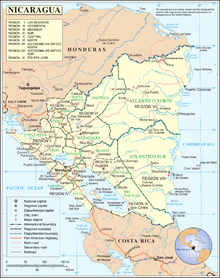
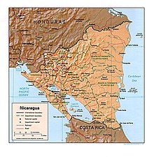
Outline of Nicaragua
Falling within the tropics, Nicaragua sits 11 degrees north of the Equator, in the Northern Hemisphere.
The country's name is derived from Nicarao,[citation needed] the name of the Nahuatl-speaking tribe which inhabited the shores of Lago de Nicaragua before the Spanish conquest of the Americas, and the Spanish word Agua, meaning water, due to the presence of the large lakes Lago de Nicaragua (Cocibolca) and Lago de Managua (Xolotlán), as well as lagoons and rivers in the region.
The term was eventually applied, by extension, to the Nicarao or Niquirano groups that inhabited that region.
The Nicarao tribe migrated to the area from northern regions after the fall of Teotihuacán, on the advice of their religious leaders.
According to tradition, they were to travel south until they encountered a lake with two volcanoes rising out of the waters, and so they stopped when they reached Ometepe, the largest fresh-water volcanic island in the world.