Outline of Wyoming territorial evolution
The following outline traces the territorial evolution of the U.S. State of Wyoming.
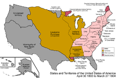 An enlargeable map of the United States after the
Louisiana Purchase
took effect on
December 20, 1803.
An enlargeable map of the United States after the
Louisiana Purchase
took effect on
December 20, 1803.
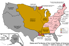 An enlargeable map of the United States after the creation of the
District of Louisiana
on
March 26, 1804.
An enlargeable map of the United States after the creation of the
District of Louisiana
on
March 26, 1804.
 An enlargeable map of the United States after the
Treaty of 1818
took effect on
October 20, 1818.
An enlargeable map of the United States after the
Treaty of 1818
took effect on
October 20, 1818.
 An enlargeable map of the United States after the
Adams–Onís Treaty
took effect on
February 22, 1821.
An enlargeable map of the United States after the
Adams–Onís Treaty
took effect on
February 22, 1821.
 An enlargeable map of the United States after
Missouri
was admitted to the
Union
on
August 10, 1821.
An enlargeable map of the United States after
Missouri
was admitted to the
Union
on
August 10, 1821.
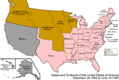 An enlargeable map of the United States after
Texas
was admitted to the
Union
on
December 29, 1845.
An enlargeable map of the United States after
Texas
was admitted to the
Union
on
December 29, 1845.
 An enlargeable map of the United States after the
Oregon Treaty
took effect
July 17, 1846
An enlargeable map of the United States after the
Oregon Treaty
took effect
July 17, 1846
 An enlargeable map of the United States after the creation of the
Territory of Oregon
on
August 14, 1848.
An enlargeable map of the United States after the creation of the
Territory of Oregon
on
August 14, 1848.
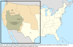 An enlargeable map of the United States after the creation of the proposed
State of Deseret
on
July 2, 1849.
An enlargeable map of the United States after the creation of the proposed
State of Deseret
on
July 2, 1849.
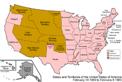 An enlargeable map of the United States after the admission of
Oregon
to the
Union
on
February 14, 1859.
An enlargeable map of the United States after the admission of
Oregon
to the
Union
on
February 14, 1859.
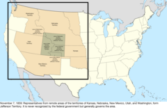 An enlargeable map of the United States after the creation of the proposed
Territory of Jefferson
on
October 24, 1859.
An enlargeable map of the United States after the creation of the proposed
Territory of Jefferson
on
October 24, 1859.
 An enlargeable map of the United States after the creation of the
Territory of Dakota
on
March 2, 1861.
An enlargeable map of the United States after the creation of the
Territory of Dakota
on
March 2, 1861.
 An enlargeable map of the United States after the creation of the
Territory of Idaho
on
March 3, 1863.
An enlargeable map of the United States after the creation of the
Territory of Idaho
on
March 3, 1863.
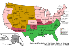 An enlargeable map of the United States after the creation of the
Territory of Montana
on
May 26, 1864.
An enlargeable map of the United States after the creation of the
Territory of Montana
on
May 26, 1864.
 An enlargeable map of the United States after the creation of the
Territory of Wyoming
on
July 25, 1868.
An enlargeable map of the United States after the creation of the
Territory of Wyoming
on
July 25, 1868.
 An enlargeable map of the United States after the admission of
Wyoming
to the
Union
on
July 10, 1890.
An enlargeable map of the United States after the admission of
Wyoming
to the
Union
on
July 10, 1890.
 An enlargeable map of the United States as it has been since
Hawaiʻi
was admitted to the
Union
on
August 21, 1959.
An enlargeable map of the United States as it has been since
Hawaiʻi
was admitted to the
Union
on
August 21, 1959.


