Territorial evolution of North America since 1763
Preferring to keep Guadeloupe, France gave up Canada and all of its claims to territory east of the Mississippi River to Britain.
Throughout this period, France maintained the small North American territory of Saint Pierre and Miquelon off the coast of the island of Newfoundland.
Likewise, Canada faced tensions between settlers, including French and English communities, and the colonial administration that led to the outbreak of civil strife in 1837.
The last major territorial change occurred when Newfoundland joined Canada in 1949,[2] but there have been a number of small adjustments like the Boundary Treaty of 1970 where the city of Rio Rico, Texas, was ceded to Mexico.
The Great Lakes basin was barred to European settlement, reserved as exclusive “hunting grounds” for the “several nations or tribes of Indians” under the king's “protection.”[5] By the Quebec Act, the territory of the Province of Quebec was expanded to take over part of the Indian Reserve, including much of what is now southern Ontario, Illinois, Indiana, Michigan, Ohio, Wisconsin, and parts of Minnesota.
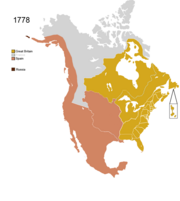
[7] In 1778, Saint Pierre and Miquelon were attacked by a force led by Newfoundland's Governor John Montagu and then population deported by the British as retaliation for French support of the American Revolutionary War.
[9] The 1783 Treaty of Paris formally ended the American Revolutionary War between Great Britain and the United States of America, which had rebelled against British rule.
The Kingdom of Great Britain recognized the territory south of what is now Canada, east of the Mississippi and north of Florida as American property.
[10] France regained Saint Pierre and Miquelon in 1783 after the Peace of Paris and some residents returned to the islands.
[11] The indigenous Koniag harassed the Russian party and Shelikhov responded by killing hundreds and taking hostages to enforce the obedience of the rest.
[12] In 1789, in attempt to assert its sovereignty over the Pacific coast the Spanish seized British ships in Nootka Sound on Vancouver Island.
In the secretly negotiated Third Treaty of San Ildefonso (formally titled the Preliminary and Secret Treaty between the French Republic and His Catholic Majesty the King of Spain, Concerning the Aggrandizement of His Royal Highness the Infant Duke of Parma in Italy and the Retrocession of Louisiana), Spain returned the colonial territory of Louisiana to France.
[26][A 2] US President James Madison proclaimed the annexation of the Baton Rouge and Mobile Districts of West Florida, declaring them part of the Louisiana Purchase.
Argentine corsair Hippolyte Bouchard and his crew unilaterally captured the Californian capital of Monterey for six days, annoying the Spanish for trade in the Pacific.
[30] The new borders intruded on Arkansaw Territory's Miller County, created on April 1, 1820, which dipped below the Red River and into land ceded to Spain.
However, rebels in one part of Chiapas, Soconusco, proclaimed its separation from Mexico on July 24, 1824, and it was formally annexed by the Federal Republic of Central America on August 18, 1824.
[19] The Platte Purchase added a small area of land to Missouri, giving it its present-day boundaries.
Its formation reflected recommendations made by John Lambton, 1st Earl of Durham in the Report on the Affairs of British North America following the Rebellions of 1837.
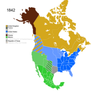
The United States Congress passed the joint resolution of annexation on March 1, 1845,[43] but Texas did not agree to join the union for some time after.
[A 3][44] The Oregon Treaty established the 49th parallel west of the Lake of the Woods as the continental border (so it did not include Vancouver Island) with the lands held by the United Kingdom.
[48] The Compromise of 1850 divided the Mexican Cession and land claimed by Texas but ceded to the federal government in exchange for taking on its debts.
Due to its nature as a mining and grazing area, land started to be added to Nevada Territory to accommodate these activities.
The Rupert's Land Act 1868 transferred the region to Canada as of 1869, but it was only consummated in 1870 when £300,000 were paid to the Hudson's Bay Company.
When the Province of Canada was formed, its borders were not entirely clear, and Ontario claimed to eventually reach all the way to the Rocky Mountains and Arctic Ocean.
Manitoba's borders were expanded to a larger postage stamp province taking land easterly from the District of Keewatin to the western boundary of Ontario.
Keewatin covered the portion of the North-West Territories north of Manitoba on the mainland, and all islands within Hudson, James, and Ungava Bays.
Alberta's western border runs along peaks of the Rocky Mountain ridge and then extends north to the 60th parallel.
[99][100] Maps prior to 1927 wildly disagreed on the actual position of the border, instead of agreeing upon marking the area as being disputed.
Disagreements persist even today (to a lesser extent), as Quebec insists on including the rest of the gulf's basin in its maps, separated with a dotted line saying 1927 border, non-final.
The Dominion of Newfoundland, because of financial difficulties, was obliged to give up its self-governing status and the Commission of Government took its place.