Pak Phanang district
Pak Phanang (Thai: ปากพนัง, pronounced [pàːk pʰā.nāŋ]) is a district (amphoe) of Nakhon Si Thammarat province, southern Thailand.
The low Talumphuk peninsula to the north of the district was completely devastated, and even in the town Pak Phanang itself the storm surge made the water rise four metres.
[2] Neighboring districts are (from the south clockwise): Hua Sai, Chian Yai, Chaloem Phra Kiat and Mueang Nakhon Si Thammarat.
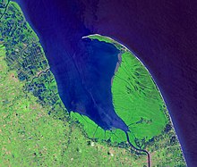
The most striking geographical feature is the long elongated peninsula known as Laem Talumphuk ('toli shad cape'), which is formed of sand deposited by the predominantly northward current interacting with the outflow of the Pak Phanang River (Thai: แม่น้ำปากพนัง).
Originally the coastline of the bay consisted of tidal flats and mangrove forests, however a lot of the western coast had been converted into shrimp farms.