Paleocurrent
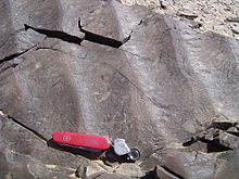
A paleocurrent or paleocurrent indicator is a geological feature (typically a sedimentary structure) that helps one determine the direction of flowing water in the geologic past.
This is an invaluable tool in the reconstruction of ancient depositional environments.
[1] There are two main types of paleocurrent indicators: Paleocurrents are usually measured with an azimuth, or as a rake on a bedding plane, and displayed with a Rose Diagram to show the dominant direction(s) of flow.
This is needed because in some depositional environments, like meandering rivers, the paleocurrent resulting from natural sinuosity has a natural variation of 180 degrees or more.
[2] Below are a partial list of common paleocurrent indicators: