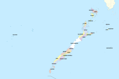
Palawan
The tiger subfossils showed longitudinal fracture of the cortical bone due to weathering, which suggests that they had post-mortem been exposed to light and air.
[16][17][18][19][20] Palawan was a major site for the Maritime Jade Road, one of the most extensive sea-based trade networks of a single geological material in the prehistoric world, operating for 3,000 years from 2000 BCE to 1000 CE.
They called it la terra de missione ("the land of promise") due to the fact that they were almost starving by the time they reached the island.
Their primary weapons were blowguns with iron tips that could both shoot thick wooden or bamboo darts (some poisoned) and function as spears once their ammunition were exhausted.
[27] Before the arrival of the Spanish in the late 15th century, Palawan broke free of the nation of Ma-i but would be conquered and ruled by Bruneian empire and their vassals the Sultanate of Sulu.
In the early 17th century, Spanish friars sent out missions in Cuyo, Agutaya, Taytay and Cagayancillo but they met resistance from Moro communities.
Before the 18th century, Colonial Authorities began to build churches enclosed by garrisons for protection against Moro raids in the towns of Cuyo, Taytay, Linapacan and Balabac.
[25] In 1818, the entire island of Palawan, or Paragua as it was called, was organized as a single province named Calamianes, with its capital in Taytay.
Early resistance leaders included Dr. Higinio Acosta Mendoza, his wife Triny, Thomas F. Loudon, and his son-in-law Nazario Mayor.
One incident was when Marcos evicted an estimated 254 families of Indigenous Tagbanwa people from the Calauit Island in order to create a game reserve full of animals imported from Africa.
[31][32] In another incident, residents of Bugsuk Island were driven from their homes and communities so that Marcos crony Eduardo Cojuangco could establish a coconut plantation.
[33] Among the leaders who helped organize the effort to prevent the eviction of the Bugsuk Island residents was United Methodist Reverend Magnifico Osorio.
[35][failed verification] This decree was later deferred on August 18 within the same year reportedly due to the opposition of the province's Sangguniang Panlalawigan (Provincial Council).
Some civil society groups and Puerto Princesa residents opposed the proposed division, claiming that there was no extensive public consultation.
The mountain heights average 1,100 meters (3,500 ft) in altitude, with the highest peak rising to 6,843 feet (2,086 m)[10] at Mount Mantalingahan.
The terrain is a mix of coastal plain, craggy foothills, valley deltas, and heavy forest interspersed with riverine arteries that serve as irrigation.
[46] When Puerto Princesa City is included for geographical purposes, its land area is 17,030.75 square kilometers (6,575.61 sq mi).
In terms of archipelagic internal waters, Palawan has the biggest marine resources that covers almost half of the Sulu Sea and a big chunk of the South China Sea that is within the municipal waters of Kalayaan Municipality which was officially annexed to the Philippine jurisdiction by virtue of Presidential Decree 1596 dated June 11, 1978.
The other, which prevails in the eastern coast, has a short dry season of one to three months and no pronounced rainy period during the rest of the year.
The southern part of the province is virtually free from tropical depressions but northern Palawan experiences torrential rains during the months of July and August.
[1] However, Palaweños criticized the move, citing a lack of consultation, with most residents in Puerto Princesa City and all municipalities but one preferring to stay with Region IV-B.
[89] The explanation the Ferdinand Marcos administration gave for establishing the park was that it was responding to the appeal of the International Union for Conservation of Nature (IUCN) to help save African wildlife.
The principal dive sites are World War II Japanese shipwrecks sunk on September 24, 1944, by United States Navy action.
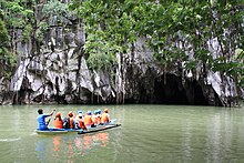
[93] Accessible by a steep 10-minute climb, the crystal-clear waters of Kayangan Lake are nestled into the mountain walls; underwater is like a moonscape.
Don't expect privacy or quiet, though, as the lake, an Instagram favorite, is overwhelmed by the cellphone-wielding masses during peak hours.
Travel + Leisure's 20 Favorite Green Hotels scored El Nido Resort's protection of Palawan's giant clam gardens and the re-introduction of endangered Philippine cockatoos.
"[96] Located in the Municipality of Taytay, this important ecological and economic zone is a watershed and fishing ground, and the habitat of Bottle-nosed and Irrawaddy dolphins.
[103] According to Palawan Electric Cooperative (PALECO), the main island composed of 19 city and municipalities, has 59% of electrification with 135,284 households connected to the grid.
Some of the private institutions are the Holy Trinity University run by the Dominican Sisters of Saint Catherine of Siena, Palawan Polytechnical College Inc., in Roxas, San Vicente and Puerto Princesa City, Systems Technology Institute (STI), AMA Computer Learning Center (ACLC) in Puerto Princesa City, San Francisco Javier College run by the Augustinian Recollect Sisters in Narra, Loyola College in Culion run by the Jesuits, St. Joseph Academy in Cuyo, St. Augustine Academy in Coron, Coron Technical School, Sacred Heart of Jesus High School in Brooke's Point; Northern Palawan Christian Institute (owned and manage by the Iglesia Filipina Independiente, Palawan Diocese) and the unique educational institution called the St. Ezekiel Moreno Dormitory located in barangay Macarascas, Puerto Princesa City, founded by Bishop Broderick Pabillo, the present auxiliary bishop of the Archdiocese of Manila.
[102] Palawan earned the third spot in the annual Condé Nast Traveler (CNT) readers' choice awards for top islands to visit in 2021.