Paleogene
[10] The Paleogene is marked by considerable changes in climate from the Paleocene–Eocene Thermal Maximum, through global cooling during the Eocene to the first appearance of permanent ice sheets in the Antarctic at the beginning of the Oligocene.
The change in climate was due to a rapid release of frozen methane clathrates from seafloor sediments at the beginning of the Paleocene-Eocene thermal maximum (PETM).
The extinction the hantkeninid planktonic foraminifera is the key marker for the Eocene-Oligocene boundary, which was a time of climate cooling that led to widespread changes in fauna and flora.
The result was a series of arcuate mountain ranges, from the Tell-Rif-Betic cordillera in the western Mediterranean through the Alps, Carpathians, Apennines, Dinarides and Hellenides to the Taurides in the east.
The irregular outlines of the continental margins, including the Adriatic promontory (Adria) that extended north from the African plate, led to the development of several short subduction zones, rather than one long system.
[14][16] Convergence between the Iberian and European plates led to the Pyrenean orogeny[17] and, as Adria pushed northwards the Alps and Carpathian orogens began to develop.
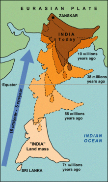
A rapid decrease in velocity to c. 5 cm/yr in the early Eocene records the collision of the Tethyan (Tibetan) Himalayas, the leading edge of Greater India, with the Lhasa terrane of Tibet (southern Eurasian margin), along the Indus-Yarling-Zangbo suture zone.
[14][23] To the south of this zone, the Himalaya are composed of metasedimentary rocks scraped off the now subducted Indian continental crust and mantle lithosphere as the collision progressed.
The microcontinent collided with southern Eurasia c. 58 Ma (late Paleocene), whilst the velocity of the plate did not decrease until c. 50 Ma when subduction rates dropped as young, oceanic crust entered the subduction zone;[25] 3) This model assigns older dates to parts of Greater India, which changes its paleogeographic position relative to Eurasia and creates a Greater India formed of extended continental crust 2000–3000 km wide.
[27] During the Late Cretaceous to Paleogene, the northward movement of the Indian plate led to the highly oblique subduction of the Neotethys along the edge of the West Burma block and the development of a major north-south transform fault along the margin of Southeast Asia to the south.
The locations of the magmatism coincide with the intersection of propagating the rifts and large-scale, pre-existing lithospheric structures, which acted as channels to the surface for the magma.
Along the central section of the North American margin, crustal shortening of the Cretaceous to Paleocene Sevier orogen lessened and deformation moved eastward.
The resulting Laramide orogeny, which began the development of the Rocky Mountains, was a broad zone of thick-skinned deformation, with faults extending to mid-crustal depths and the uplift of basement rocks that lay to the east of the Sevier belt, and more than 700km from the trench.
[33][34] Ocean-continent convergence accommodated by east dipping subduction zone of the Farallon plate beneath the western edge of South America continued from the Mesozoic.
[35] Over the Paleogene, changes in plate motion and episodes of regional slab shallowing and steepening resulted in variations in the magnitude of crustal shortening and amounts of magmatism along the length of the Andes.
[37] In the Oligocene (c. 28 Ma), the first segment of the Pacific–Farallon spreading ridge entered the North American subduction zone near Baja California[41] leading to major strike-slip movements and the formation of the San Andreas Fault.
Originally thought to be stationary within the mantle, the hotspot is now considered to have drifted south during the Paleocene to early Eocene, as the Pacific plate moved north.
At c. 47 Ma, movement of the hotspot ceased and the Pacific plate motion changed from northward to northwestward in response to the onset of subduction along its western margin.
[33]Extensional stresses from the subduction zone along the northern Neotethys resulted in rifting between Africa and Arabia, forming the Gulf of Aden in the late Eocene.
[43] To the west, in the early Oligocene, flood basalts erupted across Ethiopia, northeast Sudan and southwest Yemen as the Afar mantle plume began to impact the base of the African lithosphere.
The global climate entered icehouse conditions at the Eocene-Oligocene boundary and the present day Late Cenozoic ice age began.
[33] The initial rise in global temperatures was related to the intrusion of magmatic sills into organic-rich sediments during volcanic activity in the North Atlantic Igneous Province, between about 56 and 54 Ma, which rapidly released large amounts of greenhouse gases into the atmosphere.
For example, with the warming of the Arctic Ocean, around 70% of deep sea foraminifera species went extinct,[33] whilst on land many modern mammals, including primates, appeared.
This change of climate at about 48.5 Ma, is believed to have been caused by a proliferation of aquatic ferns from the genus Azolla, resulting in the sequestering of large amounts of CO2 from the atmosphere by the plants.
[11] As temperatures dropped at high latitudes the presence of cold water diatoms suggests sea ice was able to form in winter in the Arctic Ocean,[33] and by the late Eocene (c. 37 Ma) there is evidence of glaciation in Antarctica.
[14] Changes in deep ocean currents, as Australia and South America moved away from Antarctica opening the Drake and Tasmanian passages, were responsible for the drop in global temperatures.
[33] In the Late Oligocene, global temperatures began to warm slightly, though they continued to be significantly lower than during the previous epochs of the Paleogene and polar ice remained.
[11] Tropical taxa diversified faster than those at higher latitudes after the Cretaceous–Paleogene extinction event, resulting in the development of a significant latitudinal diversity gradient.
After the Cretaceous–Paleogene extinction event, which saw the demise of the non-avian dinosaurs, mammals began to evolve from a few small and generalized forms into most of the modern varieties we see presently.
Birds, extant dinosaurs which were already well established by the end of the Cretaceous, also experienced adaptive radiation as they took over the skies left empty by the now extinct pterosaurs.