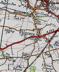
Palgrave, Suffolk
[1] It is located on the south bank of the River Waveney, opposite Diss in Norfolk and adjacent to the Great Eastern Main Line.
Palgrave has a small primary school, with St Peter’s Church located opposite, and is situated approximately 1 mile from Diss.
This particular region was found to be ideal for agricultural purposes, due to its location near the River Waverney being a direct source of water.
[6] This unknown occupational data would make it difficult to establish the overall class of the Palgrave, however it could be understood that the local society around 1881 was of a lower, working class, due to the large proportion of occupations being in labour roles such as agriculture, domestic and craftsmanship.
[8] It is clear that a slight dip in the 1961 period saw a rapid increase in the population till 2011 where it reached its peak of 905 people.
Although it is smaller than the average sized primary school, they use the supplements of Palgrave's local community centre, Church and village green to pursue in various activities.