Palmwoods-Buderim Tramway
[1] The Palmwoods-Buderim Tramway began operations in December 1914 and provided the impetus for substantial settlement expansion and economic growth in the Buderim area.
The length of the line was seven miles fifteen chains (11.6 km), which ran from the Palmwoods railway station across undulating country to Forest Glen on the Bruce Highway, and then climbed to the top of Buderim Mountain.
Shipping of farm and fruit produce from Buderim and surrounds by coastal steamer was complicated by problems with the bar and silting of the Mooloolah and Maroochy rivers.
Expectant mothers were driven to the Buderim Station by horse gig to travel to Palmwoods and thence by train to Nambour, to await the birth in one of the maternity nursing homes, there being no hospitals in the region.
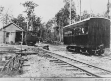
The tram consisted of perhaps some thirteen wagons, one passenger coach and a guard/brake van, pulled behind a German Krauss or American Shay steam engine.
The flat-top wagons had fruit cases placed down their centres along which planks of timber were arranged to form central seats.
[1] The tramway began to lose money in the 1920s through lower farm output with less freight revenue, in addition to the effects of a new network of main road transport introducing competition.
Other possible influences were that the operations began during World War I, curtailed any planned extensions to economically rationalise the line.
A Queensland Survey Office map of the Buderim tramway shows hand drawn lines indicating, perhaps, two alternative track extensions to Maroochydore.
The last duty of the Buderim tram was to assist in dismantling the railway by delivering the rails, which had been sold to the Moreton Sugar Mill Co., to Palmwoods.
Electrification of the main line to Nambour in 1988 has removed most signs of both the engine shed to the south and the track which reputedly returned to climb northerly to parallel the still serviceable "Buderim loop" of the government rail near the present car park.
[1] The tramway track leaves the "Buderim loop", in the Palmwoods Station yard near the present passengers' car park, and moves north to the unknown site of the former engine shed.
From the shed it apparently reversed in a turning triangle and then descended to a lower level (between three and four metres below the main line), to exit the station yard where it can be discerned to the east opposite the station building and then clearly as an embankment crossing Palmwoods Creek, before proceeding across the junction of the Chevallum and Nicklin roads to cross the Bowling Club property.
It continues beyond Lot 2 Nicklin Road for twenty-three metres of embankment ending at a small water-course where there appears to be no sign of bridge remains.
The track continues some 270 metres (890 ft) beyond the residence to the next property boundary where the remains of a small bridge or cattle grid have been pushed aside.
[1] The next property contains the extractive industrial area being operated by Queensland Sand Mining Pty Ltd situated either side of Eudlo Creek, and located at the northern end of this southern section of Winston Road South.
[1] Some remains are seen in the swampy ground in the next property, and then the track proceeds through the Land Rover garage to cross Chevallum Road and the Bruce Highway to the location of the original Forest Glen Station.
It then is well cleared as it moves through private land behind the Forest Glen Holiday Resort and commences the steady climb to Buderim.
Other features of this section are deep double- and single-sided cuttings of eight or nine metres depth through solid sandstone, sharp corners, high embankments of up to perhaps twenty to thirty metres in height, (both single and double sided), with substantial stands of varied timber with palms, ginger, orchids and other plants widely spread.
It continues climbing through the undergrowth until it becomes the drive to a Brecon Creek residence built on the easement, and then turns east to Guy Siding located behind the present kindergarten.
The tramway, through the transport and communication facilities it provided, played a central role in the development of the region, and as such is important in demonstrating the pattern of Queensland's history.
The tramway was a specific response to the economic and social pressures encountered by Australian settlers at a particular phase of the twentieth century.
The tramway demonstrates an uncommon aspect of Queensland's cultural heritage as a track with a gauge of 2 ft 6 in (762 mm), and being of private construction.
The tramway, as the transportation hub for the region, facilitated community participation in sporting and cultural events, and provided a connection to Nambour and Brisbane.