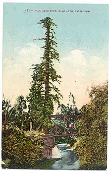
Palo Alto, California
[8] As one of the principal cities of Silicon Valley, Palo Alto is home to the headquarters of multiple tech companies, including HP, Space Systems/Loral, VMware, and PARC.
Palo Alto has also served as headquarters or the founding location of several other tech companies, including Apple,[9] Google,[10] Facebook, Logitech,[11] Tesla,[12] Intuit, IDEO, Pinterest, and PayPal.
The area of modern Palo Alto was first recorded by the 1769 party of Gaspar de Portolá, a 64-man, 200-horse expedition setting out from San Diego to find Monterey Bay.
[15] In 1777, Father Junipero Serra established the Mission Santa Clara de Asis, whose northern boundary was San Francisquito Creek and whose lands included modern Palo Alto.
In 1839, their daughter María Luisa Soto (1817–1883) married John Coppinger, who was to be, in 1841, the grantee of Rancho Cañada de Raymundo (in modern San Mateo county).
[citation needed] To the south of the Sotos, the brothers Secundino and Teodoro Robles in 1849 bought Rancho Rincon de San Francisquito from José Peña, the 1841 grantee.
Stories say the grand hacienda was built on the former meager adobe of José Peña near Ferne off San Antonio Road, midway between Middlefield and Alma Street.
[19] In 1880, Secundino Robles, father to twenty-nine children, still lived just south of Palo Alto, near the location of the present-day San Antonio Shopping Center in Mountain View.
[citation needed] The township of Mayfield was formed in 1855, around the site of a stagecoach stop and saloon known as "Uncle Jim's Cabin" near the intersection of El Camino Real and today's California Avenue in what is now southern Palo Alto.
This led them to drive the formation of a new temperance town with the help of their friend Timothy Hopkins of the Southern Pacific Railroad, who in 1887 bought 740 acres (3.0 km2) of private land for the new townsite.
The Mayfield News wrote its own obituary four days later: It is with a feeling of deep regret that we see on our streets today those who would sell, or give, our beautiful little city to an outside community.
We have watched Mayfield grow from a small hamlet, when Palo Alto was nothing more than a hayfield, to her present size ... and it is with a feeling of sorrow that we contemplate the fact that there are those who would sell or give the city away.
The Federal Telegraph laboratory site, situated at 218 Channing, is a California Historical Landmark recognizing Lee de Forest's 1911 invention of the vacuum tube and electronic oscillator at that location.
[33] Typical of the South Peninsula region of the San Francisco Bay Area, Palo Alto has a Mediterranean climate with mild, moderately wet winters and warm, dry summers.
Typically, in the warmer months, as the sun goes down, the fog bank flows over the foothills to the west and covers the night sky, thus creating a blanket that helps trap the summer warmth absorbed during the day.
Due to the Santa Cruz Mountains to the west, there is a "rain shadow" in Palo Alto, resulting in an average annual rainfall of only 15.12 inches (384 mm).
In 1909 a municipal charter created a local government consisting of a fifteen-member city council, with responsibilities for various governmental functions delegated to appointed committees.
Palo Alto, north of Oregon Expressway, is filled with older homes, including Craftsman and California Colonials, some of which date back to the 1890s but most of which were built in the first four decades of the 20th century.
South of Oregon Expressway, the homes, including many Joseph Eichler-designed or Eichler-style houses, were primarily built in the first 20 years after World War II.
[58] In the 1920s, racial covenants were used that banned "persons of African, Japanese, Chinese, or Mongolian descent" from purchasing or renting homes in many neighborhoods throughout Palo Alto.
Blockbusting refers to a practice realtors adopted in which they would advertise the incoming presence of a black family to a neighborhood, causing panic among the white residents who would consequently sell their houses at deflated prices very quickly.
The program was implemented in a way so that neighborhoods with any kind of African American population were ranked type C or D.[63] This was also the case in Palo Alto and the surrounding areas.
Palo Alto's White neighborhoods were ranked mostly Type A and B, allowing for wealth accumulation and eventually resulting in the high housing prices we see today.
[citation needed] The team, called "Gush Busters", patrolled city streets looking for broken water pipes and poorly managed irrigation systems.
[110] Palo Alto is served by two major freeways, Highway 101 and Interstate 280 and is traversed by the Peninsula's main north–south boulevard, El Camino Real (SR 82).
[115] A subway tunnel underneath the right of way and converting the old track bed into a park was also proposed, but eventually dropped after it was deemed to be too costly and concerns over environmental impacts.
The city's flat terrain and many quiet tree-shaded residential streets offer comfort and safety to cyclists, and the temperate climate makes year-round cycling convenient.
[citation needed] However, busy arterial streets which often offer the fastest and most direct route to many destinations, are dangerous for cyclists due to high volumes of fast-moving traffic and the lack of bicycle lanes.
[120] Conditions for walking are excellent in Palo Alto except for crossing high-volume arterial streets such as El Camino Real and Oregon Expressway.
An extensive urban forest, which is protected by the city's municipal code, provides shade and visual diversity, and slows motor vehicle traffic.