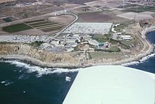
Palos Verdes Peninsula
It borders the city of Torrance to its north, the Pacific Ocean is on the west and south, and the Port of Los Angeles is to the east.
The hill cities on the peninsula are known for scenic views of the Pacific Ocean and cityscapes, distinguished schools,[3] extensive horse trails,[4] and high-value homes.
[10] Frank Vanderlip, representing a group of wealthy east coast investors, purchased 25 square miles of land on the Palos Verdes Peninsula in 1913 for $1.5 million.
[11] In 1914, Vanderlip vacationed at Palos Verdes in order to recover from an illness, and he was astounded by scenery he compared to "the Sorrentine Peninsula and the Amalfi Drive".
By 1921, Vanderlip had lost interest in overseeing development of Palos Verdes and enticed Edward Gardner Lewis to take over the project with an option to buy the property for $5 million.
Instead, he established a real estate trust, capitalizing the project through the sale of notes which were convertible to Palos Verdes property.
They were not complete, but they were substantial: improvements included many sewers, water mains, and roads; landscaping, parks, and a golf course.
[15] Palos Verdes Estates was organized and landscaped by the Olmsted Brothers and in their planning, they dedicated a quarter of the land area to permanent open undeveloped space.
The restoration project uses high-resolution multi-beam bathymetry data[18] which is an instrument that uses echo-sound to measure the depth of water at different angles to create 3D maps of the ocean floor.
By 2021, the team used Edgetech 6205 MultiPhase EchoSounder,[18] which sends and receives audible pulses that also map the ocean's floor.
Invertebrates, plankton, and several species have bioaccumulated increasing amounts of chlorinated hydrocarbons as they approach Palos Verdes.
[23] Areas of commerce include historic Mediterranean Revival style Malaga Cove Plaza and the Promenade on the Peninsula.
[25] The Palos Verdes Peninsula is within 40 minutes of both LAX and Long Beach Airport, which together provide access to most of the United States aboard all major carriers.
The former Marymount California University, a co-ed Roman Catholic four-year college was located in Rancho Palos Verdes.
[31] The peninsula is frequented by runners, hikers, horseback riders, bird watchers, surfers, scuba divers, fishermen, and bicyclists.
The most notorious surf spot for localism in Palos Verdes is Lunada Bay, which can hold any winter swell and has been known to rival Sunset Beach, Hawaii on a big day.
Localism in Palos Verdes reached a turning point in 2001 when a civil rights lawsuit was filed after a particularly violent confrontation with Hermosa Beach surfers.
[35] In 2016, The Coastal Commission targeted the group after "renewed reports that their unpermitted structure [built along Lunada Bay] was being used as a spot for ongoing bullying and intimidation."
On July 12, 2016, City Manager Tony Dahlerbruch recommended the removal of the illegal structure after pressure from the California Coastal Commission.
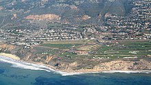
The 18th hole of the prior golf course fell victim to a landslide caused by a leak in the sanitary pipes underneath it.
The reserves contain coastal sage scrubs habitats, a community of fragrant and drought resistant shrubs and flowering plants.