Paniri
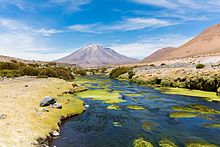
Paniri (Aymara for "he who comes, visits"[4]) is a stratovolcano located in El Loa Province, Antofagasta Region, Chile, and near the border with Bolivia.
Other than Paniri, other volcanoes in the Central Volcanic Zone are Lascar, Sabancaya and Ubinas, as well as geothermal fields such as El Tatio.
[11] The basement that Paniri is constructed on consists of both Oligocene-Miocene sediments of the San Pedro formation and ignimbrites of Miocene age which are formed by rhyodacitic and rhyolitic material.
[15] Paniri has erupted rocks ranging from basaltic andesite to rhyolite,[7] which mainly define a potassium-rich calc-alkaline volcanic suite.
[16] Phenocrysts include biotite, clinopyroxene, hornblende, olivine, opaque minerals, orthopyroxene, plagioclase, quartz and rutile; the exact composition varies between various units.
[24] These two units define the "shield" stage of Paniri, the longest lasting and most voluminous phase of volcanic activity at this volcano.
[25] Afterwards, the widespread Las Lenguas unit was emplaced which consists of blocky lava flows with some thin pyroclastic deposits.
More restricted in exposure is the Las Negras unit, which forms basalt-andesite lava flows with prominent levees on the northwestern flank of Paniri (one of these is dated to 402,000 ± 46,000 years ago).
The last unit, Llareta, was erupted by the summit vent which generated lava flows on the northeastern and southwestern sectors of the volcano, plus large pyroclastic bombs.
[27] Electric conductivity anomalies imply that there is still a geothermal system under Paniri; a magma chamber may not be sufficiently visible.