Pella, Jordan
It is located near a rich water source within the eastern foothills of the Jordan Valley, close to the modern village of Ṭabaqat Faḥl (Arabic: طبقة فحل) some 27 km (17 mi) south of the Sea of Galilee (Lake Tiberias).
[2] The Macedonian name Berenike was often used in the royal family of Ptolemaic Egypt, who conquered southern Syria and thus Pella in 301, and ruled over the city until 218 BCE, when they lost it to the Seleucid king Antiochos III.
The University of Sydney's Pella Excavation Project discovered at Tabaqat Fahl the remains of Neolithic housing dated to ca.
[15] The official University of Sydney excavation page only mentions Early Bronze Age stone defensive platforms from ca.
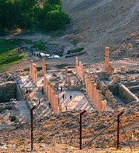
[citation needed] As yet no public buildings from the Hellenistic period have been identified, although well-appointed private houses attest to their integration into the wider norms of urban living, such as wall-paintings and statuary.
From Josephus, it is clear that Pella had been damaged and so needed some restoration by Pompey decades afterwards, but his specific reference to the destruction of Pella by Jannaeus because its inhabitants refusing to follow Jewish customs, seems to refer to a different place (Antiquities, XIII.395-397): it is listed as if amongst southern Levantine cities and out of its more normal sequence between Gadara, Gerasa and Scythopolis.
[16] A group of cities claiming Greek Hellenistic foundations asked Pompey to avoid incorporation within Rome's new client-state of Hasmonaean Judaea.
[25] Similarly to Epiphanius, Eusebius of Caesarea recounts how Pella was a refuge for Jerusalem Christians who were fleeing the First Jewish–Roman War in the 1st century CE.
The access streets were lined with newly built shops and large buildings, serving both commercial and residential functions.
This concern with urban development matched similar activities in other Decapolis towns, such as Gadara (Umm Qays) and Gerasa (Jerash/Jarash), and reflects the role of regional centres in serving local populations during late antiquity.
[29] Rather, the churches, markets and houses of Pella continued in use, with the archaeology showing their progressive modification to meet evolving social and political conditions, as in many of the other towns of the Decapolis alliance in north Jordan.
In particular, a large market and workshop area was installed adjacent to the Civic Complex church at the heart of the Byzantine town plan.
[30] Umayyad Pella, which by the eighth century CE had officially returned to its original Semitic name of Fihl (variant of Pihil), was totally devastated by the massive 749 Galilee earthquake, as a Jordan Valley rift fault line runs directly under the site.
The stone and mudbrick two-storeyed houses on the top of the tell (main mound) collapsed in on themselves, thereby trapping the inhabitants – human and animal – and preserving a rich collection of finds sourced from distant regions, such as Egypt and the Arabian Peninsula.
[31] Subsequent settlement at Pella, dated from the later eighth to eleventh centuries CE (from the Abbasid into the Fatimid period), was reduced in size, but featured an enclosed double-courtyard architectural complex in the valley immediately north of the tell.
[citation needed] Evidence for a presence in the Crusader period (12th century CE) is slight – a few pottery sherds only – but in the following Ayyubid and Mamluk periods the flat summit of the tell was inhabited by a large village, featuring a stone-built mosque with a minbar (pulpit), residential compounds defined by lane ways, and a large cemetery.
[13] Late 16th century Ottoman defters list a village called Fahl el Tahta in the administrative district of Ajlun where wheat, barley, and sesame were grown and taxes collected on goats, beehives and water-driven mills.
[34] The site was first published as part of a regional survey by G. Schumacher,[35] but the first excavation was conducted by Funk and Richardson only in 1958, revealing Bronze and Iron Age material in two soundings.
[36] From 1966–1967, R. H. Smith led a team from Wooster College (Ohio) to prepare a plan of the site and its environs, and begin excavations, but was interrupted by the Six Day War.
[38] Between 1994 and 1996, Pam Watson (at the time, Asst Director of the British Institute at 'Amman) and Dr Margaret O'Hea of the University of Adelaide conducted the Pella Hinterland Survey to identify land-use in an area approx.
[39] Since the 1990s, with the project headed by Stephen Bourke, the focus has been on the site's Bronze and Iron Age temples and administrative buildings.