U.S. Route 13 in Pennsylvania
From the state line, the route has a grade crossing with a railroad spur and passes through Sunoco's Marcus Hook Industrial Complex.
The road narrows to two lanes and crosses a railroad spur at-grade serving the industrial complex before it heads into the commercial center of Marcus Hook as 10th Street, intersecting the southern terminus of PA 452.
continues northeast along Post Road and US 13 turns southeast for a concurrency with PA 291 on two-lane undivided Price Street.
The two routes make a sharp curve to the northeast and become West 2nd Street, crossing into the city of Chester and running through urban residential and industrial areas.
US 13/PA 291 continues northeast and becomes a five-lane road with a center left-turn lane as it passes more urban development and empty lots.
The road continues through commercial areas and US 13 splits from PA 291 by turning north onto two-lane undivided Morton Avenue.
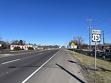
The road passes under Amtrak's Northeast Corridor railroad line and runs through urban areas, intersecting the northern terminus of US 13 Bus.
The road passes a mix of homes and businesses before it comes to a bridge over Crum Creek, at which point it fully enters Ridley Township.
The route passes under I-95 and continues past commercial development in the community of Crum Lynne, gaining a center left-turn lane.
The route continues past suburban homes and businesses as a four-lane undivided road, passing to the southeast of Taylor Hospital.
There, US 13 passes south of Sharon Hill station which serves as the terminus of the SEPTA Route 102 trolley line before continuing past more development.
The road curves north at the point it crosses over a short tunnel carrying CSX Transportation's Philadelphia Subdivision railroad line and enters the borough of Collingdale, continuing to an intersection with MacDade Boulevard.
The route passes to the west of the bus terminal at SEPTA's Darby Transportation Center and curves northeast at the Main Street intersection into urban neighborhoods, narrowing to two lanes.
Here, US 13 turns east onto Baltimore Pike and runs between Fernwood Cemetery to the north and urban residential and commercial development to the south.
Immediately after crossing the creek, the road comes to the Angora Loop at 61st Street, which serves as the terminus of the SEPTA Route 34 trolley line.
At this point, the trolley tracks follow Baltimore Avenue as it continues through urban neighborhoods consisting of rowhouses along with a few businesses.
The route comes to bridges over CSX Transportation's Trenton Subdivision and the Northeast Corridor railroad lines before it runs between wooded Fairmount Park to the west and the urban Strawberry Mansion neighborhood to the east, intersecting Cecil B. Moore Avenue east of SEPTA's 33rd and Cecil B. Moore Bus Loop.
The road continues into North Philadelphia and heads into urban areas of homes, businesses, and industry, crossing Allegheny Avenue and passing northwest of Mercy Career & Technical High School before reaching bridges under SEPTA's Manayunk/Norristown and Chestnut Hill West lines.
The route passes north of Simon Gratz High School Mastery Charter before it intersects Germantown Avenue and comes to a bridge over CSAO's Richmond Industrial Track line.
The road continues through developed areas and passes northwest of SEPTA's Gregg Street Bus Loop before it crosses Grant Avenue.
US 13 continues past a mix of residences and commercial establishments in the community of Cornwells Heights, passing northwest of Holy Ghost Preparatory School.
Farther northeast, the road comes to a partial cloverleaf interchange with PA 132 immediately northwest of that route's eastern terminus at I-95.
US 13 continues through the northern part of the borough of Bristol, running through commercial areas and passing to the west of residential neighborhoods.
The route reenters Bristol Township upon crossing Adams Hollow Creek and passes through commercial areas with some woods before coming to an intersection with a ramp that provides access to the Pennsylvania Turnpike (I-95) at an interchange.
[2][5] Bristol Pike splits off to the northeast and US 13 heads north as a freeway, forming the border between Tullytown to the west and Falls Township to the east.
Following this, the route passes between the planned residential suburb of Levittown to the west and Falls Township Community Park to the east.
Published in 1940, the Pennsylvania Guide noted that, between Glenolden and Darby, "US-13 now occasionally coincides with the Queen's Highway, an important Colonial road.
[11] This turnpike ran between Front Street and Germantown Road in Northern Liberties and a ferry across the Delaware River in Morrisville via Frankford and Bristol.
[16] With the creation of the U.S. Numbered Highway System in 1926, US 13 was designated through Pennsylvania from the Delaware border in Marcus Hook northeast to US 1/PA 1 at Bridge Street in Morrisville.
However, this plan was opposed by New Jersey officials and I-95 was instead routed to bypass Trenton to the north, crossing the Delaware River on the Scudder Falls Bridge.