Pfrimm
After entering the Alzey Hills, the Pfrimm takes up the Bornbach and then flows northeastward past Standenbühl, while the Donnersberg mountains are a few kilometers further northeast.
Between Standenbühl and Dreisen, the Münsterhof, the former Premonstratensian abbey Münsterdreisen [de], is situated on the Pfrimm's southern shore.
In Marnheim, the Gerbach joins, also from the west; at this point the Pfrimm Viaduct used to span the river, until it was demolished in 1945.
From here, the Pfrimm flows past Albisheim, then the Leiselsbach [de; eo] joins from the northwest.
To the west of the village, we find the recreational area Wiesenbrünnchen and the first of two so-called ox pianos (river crossings, see below).
It follows the Leiselheimer Damm (also known as the Pfrimmdamm), which was constructed in the Middle Ages and raised in 1841 as part of a Pfrimm improvement project.
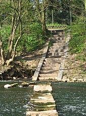
The Pfrimm flows through the 300-metre (980 ft) long Pfrimmweiher pond and into the Karl-Bittel-Park [de; fr] (also known as Pfrimmpark), where the other "ox piano" can be found.
The water flowed into Gaustraße street in the district of Neuhausen [de; fr], north of the Worms Central Station.
A much older ox piano could be found in the western part of in Pfeddersheimer, approximately in the middle of the Enzingerstraße.
Here, a concrete dam and a weir were used to hold back the water and divert it into the (now abandoned) Mühlbach ("Mill Brook").
Here, too, and "ox piano" was constructed, allowing pedestrians to cross the Pfrimm with dry feet, if the water level permitted.