Point Lobos
The sea near Point Lobos is considered one of the best locations for scuba diving on the Monterey Peninsula and along the California coast.
[2] Point Lobos is just south of Carmel-by-the-Sea, California, United States, and at the north end of the Big Sur coast of the Pacific Ocean.
Engineer Alexander Allan purchased the land and over many years bought back the lots that had been sold and erased the subdivision from the county records.
As of 2017[update], more than one million annual visitors from around the world visited Point Lobos, which is restricted by only 150 on-site parking spaces.
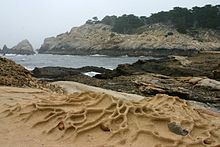
[3][4] The Point Lobos area is geologically unique and contains a rich and diverse plant and animal life both on shore and in the water.
Called the "greatest meeting of land and water in the world" by Australian-born landscape artist Francis McComas,[5][6][7] The Carmel submarine canyon lies just north of Point Lobos.
The quality of the underwater environment in the adjacent marine protected areas draws a large number of scuba divers.
The Point Lobos Foundation has coordinated volunteer days with the goal of planting hundreds of native species to restore eroded areas.
Similar studies in marine protected areas located off of the Santa Barbara Channel Islands have already detected gradual improvements in fish size and number.
The museum also highlights the history of Point Lobos, including its cinematic appearances and plans at the turn of the 20th century to develop the area for densely packed suburban housing.
Evidence has been found of a long-term village named Ichxenta, in a meadow near San Jose Creek adjacent to Point Lobos, that indicates the natives inhabited the area for about 2,500 years.
[19][18]: 37 In about 1770, Spanish vaqueros from nearby Carmel Mission ran large herds of cattle in the area near Point Lobos.
[20][21] Ichxenta was likely occupied until near the end of the Carmel Mission era, when the native population was decimated by disease, starvation, overwork, torture, and forced assimilation.
[22]: 114 Governor Juan Bautista Alvarado granted Rancho San Jose y Sur Chiquito, two square leagues of land, in 1839 to Marcelino Escobar, Alcalde (or mayor) of Monterey, Alta California.
[18][20] Ownership of Point Lobos was later complicated by the fact that when Juan and Augustin Escobar sold the rancho to Josefa de Abrego in 1841, they didn't obtain permission from their multiple brothers and sisters.
Records confirm the soldiers paid nothing, and a legend attached to the transfer says a gambler lost a rancho in a card game.
[18] On June 7, 1844, the soldiers turned the Rancho over to their superior officer, Colonel José Castro, former Governor Alvarado's brother-in-law.
Castro filed a claim on February 2, 1853,[18] but grew impatient with the outcome and sold the land in 1854 to Joseph S. Emery and Abner Bassett for $700, leaving to them the legal fight for ownership.
[18] In 1880, a lawsuit was filed in United States District Court to resolve the conflicting claims of more than two dozen putative property owners and squatters.
The title was confirmed on December 24, 1885, and President Grover Cleveland signed the land patent on May 4, 1888, 35 years after Castro's initial filing.
In 1874, a seam of low grade bituminous coal was found in upper Malpaso Canyon, southeast of Pt Lobos.
[31] On September 6, 1888, shortly after the patent for Rancho San Jose y Sur Chiquito was approved, almost all of the owners banded together to form the Carmelo Land and Coal Company.
They begin selling lots for $25 to $50 for a new town they initially named Point Lobos City, but later renamed Carmelito.
In 1899 he had a narrow gauge railroad built from nearby San Jose Beach to Coal Chute Point to transport sand for shipment by sea to glass manufacturers in Alameda.
The Allan family put up toll gates, prohibited camping, and charged visitors 50 cents a vehicle (about $10 today) to enter the point.
[35][20][21][12] Scientists reported to the government that the Carmel area including Point Lobos was the "most picturesque spot on the Pacific Coast."
[18] Duncan McDuffie of the Save the Redwoods League hired the internationally known landscape architect Frederick Law Olmsted to research Point Lobos and report on the areas most noteworthy of preservation.
Olmstead's report described Point Lobos as "the most outstanding example on the coast of California of picturesque rock and surf scenery in combination with unique vegetation, including typical Monterey cypress.
"[36] Point Lobos gained the attention of the newly established California State Park system, who considered taking the land using eminent domain.
The state promptly set about erasing evidence of human intrusion on the land, removing man-made structures like the abalone cannery, the railroad used to haul sand, and a number of homes and shacks, excepting a single Whalers Cabin.