Los Padres National Forest
Administered by the United States Forest Service, Los Padres includes most of the mountainous land along the California coast from Ventura to Monterey, extending inland.
The northern division lies within Monterey County and includes the Big Sur Coast and its scenic interior areas.
The Santa Ynez Mountains, which are within the Los Padres, rise above the Gaviota Coast, a series of alluvial plains along the last undeveloped stretch of the Southern California coastline.
[5] Many rivers in Southern and Central California have their points of origin within the Los Padres National Forest, including the Carmel, Salinas, Cuyama, Sisquoc, Santa Ynez, Coyote Creek, Sespe, Ventura, and Piru.
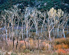
[10] Many vegetation types are represented in the Los Padres, including chaparral, the common ground cover of most coastal ranges in California below about 5,000 feet (1,500 m), and coniferous forests, which can be found in abundance in the Ventana Wilderness as well as the region around Mount Pinos in northern Ventura County.
Seven environmental groups, the city of Ojai and Ventura County filed three lawsuits in federal court in April 2022 to stop the brush clearance and logging operation.
Restrictions were put in place at times during the COVID-19 pandemic due to crowded conditions in which people were unable to social distance and also the resulting litter and human waste that was left behind.
[17] Los Padres means "the Fathers", referring to the Catholic missionary priests of the Spanish missions who proselytized in and around the area in the 18th and 19th centuries.
In 1965, a truck driven by country singer Johnny Cash caught fire, and burned several hundred acres in Ventura County.
[20] In August 1977, the Marble Cone Fire burned 178,000 acres (720 km2)[21] within the Ventana Wilderness and other portions of the Los Padres Forest.
The region experienced an on-and-off Santa Ana wind event for a little over two weeks, which contributed to the Thomas Fire's persistent growths in size.
The Forest Service conducts prescribed burns when favorable weather conditions are present; temperatures must be below 80 degrees, winds lower than 15 miles per hour and relative humidity needs to be above 20 percent.