Durban
In 1824, English traders from Cape Colony, led by Francis Farewell and Henry Fynn, established a trading post at Port Natal, and later that year, Shaka, the Zulu king, granted them land around the Bay.
Historically, it was a popular tourist destination domestically because of its beaches and warm climate,[9] but in recent years, tourism has declined.
[10][11] Some notable places are the Golden Mile beachfront, Botanic Gardens, the Art Gallery and Natural Science Museum at City Hall, the Tudor-style Playhouse Theatre, uShaka Marine World, and the International Convention Centre.
[12] As of 2018, the metro area contributed 59.9% and 9.6% to the provincial and national gross domestic product, respectively; the main sectors were finance, community services, manufacturing, trade, transport, and tourism.
[16] In 1686, a ship from the Dutch East India Company named Stavenisse was wrecked off the eastern coast of South Africa.
Some of the survivors made their way to the Bay of Natal (Durban) where they were taken in by the "Abambo" tribe (Hlubi people), which was led by Chief Langalibalele.
A formal contract was drawn up by Laurens van Swaanswyk and signed by the chief of the Abambo people, with the crew of the Stavenisse acting as translators.
[17] By 1822, James Saunders King, captain of the British ship Salisbury, together with Lt. Francis George Farewell, both men being former Royal Navy officers from the Napoleonic Wars, were engaged in trade between the Cape and Delagoa Bay.
[citation needed] The modern city of Durban thus dates from 1824, when the settlement was established on the northern shores of the bay near today's Farewell Square.
A local trader Dick King and his servant Ndongeni were able to escape the blockade and rode to Grahamstown, a distance of 600 km (370 mi) in fourteen days to raise reinforcements.
[21] Fierce conflict with the Zulu population led to the evacuation of Durban, and eventually the Afrikaners accepted British annexation in 1844 under military pressure.
[citation needed] The blazon of the arms registered by the South African Bureau of Heraldry and granted to Durban on 9 February 1979.
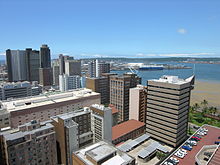
The extent of urban sprawl the Greater Durban agglomeration has experienced, virtually adjoining surrounding smaller towns, has made boundaries in the metropolitan area quite complicated.
[29][30] However, the eThekwini Metropolitan Municipality is an amalgamation of Durban proper and more than 120 other nearby formerly independent towns and suburbs such as Amanzimtoti, Cato Ridge, Chatsworth, Hillcrest, KwaMashu, Inanda, oThongathi, Pinetown, Queensburgh, uMhlanga, Umlazi, Verulam and Westville among others that have organically merged yet still retain their legal boundaries.
The Warwick Junction Precinct is home to a number of street markets, with vendors selling goods from traditional medicine, to clothing and spices.
From its earlier years to the present, many layers have added to Durban's architectural heritage: Victorian, Edwardian, Islamic, Hindu, modernist, and contemporary.
The Zulu language Ukhozi FM has a huge national listenership of more than 6.67 million, making it the second largest radio station in the world.
The other SABC national stations have smaller regional offices in Durban, as does TV for news links and sports broadcasts.
The airport's position forms part of the Golden Triangle between Johannesburg and Cape Town, which is important for convenient travel and trade between these three major South African cities.
In 2012 a decision was made to renovate and expand the facilities back up to a full naval base to accommodate the South African Navy's offshore patrol flotilla.
[89] The city's main position as a port of entry onto the southern African continent has led to the development of national roads around it.
The N3 Western Freeway starts in the central business district and heads west under Tollgate Bridge and through the suburbs of Sherwood and Mayville.
The EB Cloete Interchange (which is informally nicknamed the Spaghetti Junction) lies to the west of Durban and east of Westville, allowing for transfer of traffic between the N2 Outer Ring Road and the Western Freeway.
It provides a vital link to the coastal towns (such as eManzimtoti, Kingsburgh, Scottburgh, eMkhomazi, Ballito and KwaDukuza) that rely on Durban.
Durban also has a system of freeway and dual arterial metropolitan routes, which connect the sprawling suburbs that lie to the north, west and south of the city.
It passes through the seaside towns and villages of La Mercy and eMdloti before becoming a dual carriageway in uMhlanga, north of Durban and ending at the northern edge of the CBD.
The M13 (King Cetshwayo Highway) is an untolled alternative to the N3 Western Freeway (which is tolled at Mariannhill) and is an important commuter route linking the nearby towns and suburbs to the west of Durban such as Hillcrest, Gillitts, Kloof, Pinetown and Westville to the city.
The Democratic Alliance, Inkatha Freedom Party, and Minority Front were concerned with their lack of participation in the process, and that the emphasis on individuals affiliated with the ANC presented a partisan image of the anti-apartheid struggle.
[97] Since 2017, the newer Durban People Mover Bus System that runs along certain routes has been testing out free Wi-Fi for passengers.
Police station precincts recording the lowest murder rates per 100,000 in 2017 were Durban North (7), Mayville (8), Westville (12) and Malvern (12); while some of the most dangerous areas were Kwamashu (76) and Umlazi (69).