Post Instrument
It was used during the period from the mid-1930s into the early 1950s, and was one of the main sources of daytime tracking information during World War II.
The ROC also developed a methodology that allowed the Post Instrument to be used to produce measurements purely by sound, but it is unclear how often this was used.
Prior to the introduction of radar, optical tracking systems of widely varying complexity were commonly used to spot and report aircraft positions.
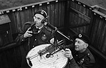
[2] The original Post Instrument was mounted on a metal rod extending vertically from the centre of a circular table.
[2] The vertical rod of the original version was replaced by a horizontal framework, roughly T-shaped, that was suspended above the table on three wheels running on a metal track around the rim of the map.
Micklethwait was an observer at the Gower Street Post on the roof of a building at University of London, near Euston Square tube station.
Two or more posts had to work in concert to use the system, using two measured angles and simple trigonometry to solve the altitude.
Other posts that could see the same aircraft would continue to track the target as normal, set to whatever altitude they had initially estimated.
At this point they would stop measuring the aircraft and instead crank the Corrector until its pointer lay over the marking on the map indicating the location of the first post.
This correction was called to the ROC center who then forwarded it to all the posts in the area to update their altitude settings to 11,000 feet.
They would then crank the Corrector until its pointer lay directly above the nearest point on the ruler, and the correction could then be read off as normal.
The operators at the posts would then crank the Corrector until its pointer lay over the calculated grid location, at which point the correction could be read.
This basically consisted of moving the horizontal slider until the indicator pointer was over the "sound line", a circle on the map representing a 5 miles (8.0 km) distance around the post.
In this system, originally set up by Edward Ashmore, observers telephoned reports of aircraft to a plotting center in the Horse Guards building in London.
It was re-organized and expanded, covering not only the London area but adding similar reporting organizations in The Midlands.
[12] In the new systems, plotters would take the reports from the observers and place a colored marker on a large map inside the indicated grid location.
This produced a trail of colored markers on the map that allowed observers to easily see the track of the aircraft, as well as estimate how quickly it was moving.