Prehistory of West Virginia
The artifacts uncovered in these areas give evidence of a village society with a tribal trade system culture that included limited cold worked copper.
[12] State universities and the U.S. Geological Survey paleoanthropologists have found evidence of early Archaic people habitating the region during the Holocene Climate Optimum — a rough interval of 9,000 to 5,000 years B.P.
The western and northern valleys of West Virginia became warm and dry with less precipitation around 2550 BCE, causing the bottom land flora to thin out and creating occasional major floods and serious erosion during the early part of this transitional weather pattern.
A few uncommon Pointed Pole Adzes are thought to have been used for heavy woodworking at one late northern Panhandle Archaic site (2000 BCE), where a dugout canoe has possibly been found.
[58] The Fort Ancient hamlet and companion crop fields era, beginning with (46WD1) Blennerhassett Island Mansion (891–973 CE),[59] differentiate the Late Woodland Wood Phase of the Eastern Agricultural Complex in west-central West Virginia.
Montane (500–1000 CE) locations include the tributaries of the Potomac on the Eastern Panhandle region which also was influenced by the Armstrong culture and Virginia Woodland people.
"[65] Childers phase occupation at multiple strata Parkline Site (46PU99), Putnam County, West Virginia, is most likely associated with populations living in the Scioto Valley of Ohio of early Late Woodland, around 400 CE (CRAI 2009[66]).
It is represented by numerous thermal features, including large, rock-filled earth ovens on the Kanawha Valley having its origin on the northeast Atlantic Seaboard dating to 900 CE.
[89] Their obtuse-angle clay pipes are similar to those found on the various Delmarva Peninsula complexes of coastal Maryland and Virginia, to northeast North Carolina.
[92] "Shell mask gorgets with weeping eye designs are commonly found in East Tennessee, northeast Arkansas, and the middle Ohio Valley on sites dating to the Protohistoric period or just prior to it,[93] quoting David Pollack, Kentucky Heritage Council.
Though unseen in West Virginia, some houses in the central Ohio Valley would have mud daubed sides similar to Mississippian according to Peregrine and Ember publishing of 2002.
Predating classic Mississippian influence at a great distance down river (Pauketat, 1050 CE "Big Bang" of Cahokia), George describes Drew pottery as like a "bean pot" or "more squat."
Monongahela tribe roots are in farm fields and hamlets with no palisading walls, on the major broad river valleys following the late Watson people.
To quote the Maryland Archaeological Conservation Lab, "Monongahela ceramics are a complex series that begin with an early grit or limestone tempered group and end with a very anomalous collection of types found in southwestern Pennsylvania during the post-Contact period.
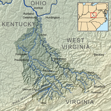
Carbon and Barker's Bottom; on the Guyandotte Valley: Gue, Logan and Mann sites, and the Dingess village nearby on the Tug Fork-Levisa Fork of the Big Sandy.
Bluestone phase (Fort Ancient tradition, highland farmers) is of Southern West Virginia easternmost Cumberland (La Posta Volume 38 No 2 variously, Waseoto, Osioto, Osiata, Oseoto, and Onosiota[112]) and south Allegheny valley's watershed.
[114][115] The Clover Complex spans Putnam, Mason and Cabell counties along the lower Great Kanawha and Ohio rivers overlapping a central area of the older west-central Feurt phase.
Along the western routes of tributary streams, points made of material from SE Ohio and W Pennsylvania are some times found on the surface north from the Great Kanawha.
Another very similar small, slender long triangle of Piedmont Plateau Late Woodland called the Uwharrie projectile point type also follows the larger elongated Yadkin and early large Levanna.
[123] The similar point, local southwest Altizer and some Feurt variants with hints of "ears" (Hamilton-like), also appear in central Ohio Valley and dates CE 1400 (Carmean 2009[124]).
Using a similar flaking technique, the lighter Caraway Triangular point dominates at the time when the incised rattlesnake gorgets influence from northwest Tennessee and southwest Virginia are found in several burials at site 31SK15.
Excavations at Site 31SK15 by Coastal Carolina Research, Inc. (page 14) indicate, "New ceramic styles may reflect interaction with the chiefdoms of the Catawba, Pee Dee, or Wateree drainages to the south (Eastman 1996)."
In the same time frame, the central and southwest Ohio (Till Plains) had cooler and wetter conditions, which affected the 'silking', pollination and grain filling stages that likely caused lower yields.
[19] Dr. McMichael explained that warfare can be assumed, as some corpses with projectile points in them were found at the last occurrence of a culturally uncommon large palisaded Fort Ancient village at the Buffalo Site, 46PU31.
[19] With advanced hunting tools in hand, and a changed focus, these people now seasonally break away from the town to winter camps up river tributaries to gather fur for trade.
The narrower bottom creeks become brooks flowing around cliff ridge-lines and rolling hills on enveloped[clarification needed] terraces feeding the bottomland of major rivers.
Below the mouth of Paint creek there was a large "flat sided" stone embedded in the river, which the early settlers called the "picture rock" with many animals, and one person, engraved on it.
Jonathan P. Kerr writes, "Traditionally, archeologists distinguish the Woodland period from the preceding Archaic by the appearance of cord-marked or fabric-marked pottery, the construction of burial mounds and other earthworks and the rudimentary practice of agriculture (Willey 1966:267).
Maryland sites with Page components include Nolands Ferry (18FR17)*, Mason Island (18MO13)*, Cresaptown (18AG119), Barton (18AG3), Sang Run (918GA22)*, Friendsville (18GA23)* (* collections at MAC Lab).
[161] Feurt-incised pottery (beginning around 1100 CE) of the Fort Ancient Tradition appears along today's Ohio and West Virginia state bordering shores using shell tempering with its decorated incised oblique lines.


Neibert Mound site