Transport in Sydney
Sydney's early urban sprawl can be traced in part to the development of its passenger rail network as well as the availability of the automobile as the dominant mode of transport–a similar history has shaped the transport and infrastructure of most major Australian cities.
This rail infrastructure allowed working-class suburbs to develop at a large distance from the city centre.
[2] In terms of effectiveness and sustainability of public transport, Sydney lagged behind Brisbane and many other cities in a 2017 study by design firm Arcadis, where it was ranked at 51.
Sydney's suburban commuter rail service consists of a complex system of integrated railway lines, of which most run through the city underground.
This station is also the terminus for NSW TrainLink's long-distance trains to numerous destinations in country New South Wales as well as Melbourne and Brisbane.
Construction is currently underway for the second phase of the line, where it will eventually pass through the city and then travel south-west to Bankstown.
Work is progressing to extend this line from Chatswood to Bankstown, running under Sydney Harbour and the CBD with a scheduled 2025 completion.
Sydney is the first and currently the only Australian city with a fully automated rapid transit metro system.
[7][8] Despite extensive plans for an underground network in the past, disputes over privatisation and funding had hampered government approval, delaying its inception.
In spite of difficulties getting the project off the ground, government approval for what was initially known as the North West Rail Link, Sydney's first underground metro, was given in 2013.
This was a series of projects along the Main Northern line between Sydney and Newcastle aimed at increasing the number of freight trains operating along the route.
Freight operators include Aurizon, Crawfords Freightlines, Southern Shorthaul Railroad, Pacific National, Qube Holdings and SCT Logistics.
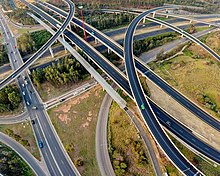
They include: In Sydney, an expansive network of various motorways and roads play a substantial and fundamental role, spurred by a high reliance on motoring as a means of transport.
[17] Collectively, 160 kilometres of motorways, freeways and tolled roads serve the Greater Sydney area and on average, the majority of households rely on at least 1 or 2 cars as a means of transport.
[18] However, despite this high reliance on roads, Sydney still maintains the highest rate of usage of public transport in Australia.
(the full list of main roads gazetted appears in the Government Gazette of the State of New South Wales of 17 August 1928).
Sydney has a hilly topography and so may require a slightly higher level of fitness from cyclists than flatter cities such as Melbourne and Canberra.
[21] Historically, bicycle infrastructure was largely constructed in areas for recreational riding or along shared paths such as in parks.
In general, individual taxis are owned by small-scale operators who pay membership fees to regional or citywide radio communication networks.
The average amount of time people spend commuting with public transport in Sydney, for example to and from work, on a weekday is 82 minutes.