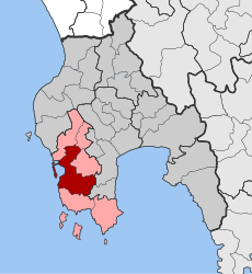
Pylos
The area remained under Ottoman control, with the exception of a brief period of renewed Venetian rule from 1685–1715 and a Russian occupation from 1770–71, until the outbreak of the Greek War of Independence in 1821.
It starts in the depths of prehistory, as the region has been inhabited since the Neolithic, when populations from Anatolia began to spread in the Balkans and Greece around 6500 BC, bringing with them the practice of agriculture and farming.
Excavations have demonstrated a continuous human presence from the Late Neolithic period (5300 BC) on several sites of Pylia, in particular in those of Voidokilia and of Nestor's cave, where numerous ostraca or fragments of painted, black and polished ceramics have been found, as well as later engraved and written pottery.
[10] The Mycenaean state of Pylos (1600–1200 BC) covered an area of 2,000 km2 (770 sq mi) and had a minimum population of 50,000 according to the Linear B tablets discovered there, or even perhaps as large as 80,000–120,000.
The various archaeological remains of palaces and administrative or residential infrastructures that have been found in the region so far suggest to modern scholars that the ancient city would have developed over a much larger area, that of the Pylia Province.
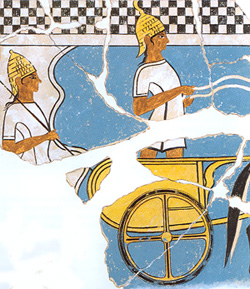
In addition to the archaeological remains of the palace, Blegen also found there thousands of clay tablets with inscriptions written in Linear B, a syllabic script used between 1425 and 1200 BC for writing Mycenaean Greek.
Thucydides has given a minute account of the topography of the district, which, though clear and consistent with itself, does not coincide, in all points, with the existing locality, Thucydides describes the harbour, of which the promontory Coryphasium (Koryphasion) formed the northern termination, as fronted and protected by the island Sphacteria, which stretched along the coast, leaving only two narrow entrances to the harbour,--the one at the northern end, opposite to Coryphasium, being only wide enough to admit two triremes abreast, and the other at the southern end wide enough for eight or nine triremes.
According to the French and Greek versions of the Chronicle, Nicholas II of Saint Omer, the lord of Thebes, who in c. 1281 received extensive lands in Messenia in exchange for his wife's possessions of Kalamata and Chlemoutsi, erected a castle at Navarino.
[34] From the early years of the 15th century, Venice set its eyes on the fortress of Navarino, fearing lest its rivals the Genoese seize it and use it as a base for attacks against the Venetian outposts of Modon and Coron.
In 1685, during the early stages of the Morean War, the Venetians under Francesco Morosini and Otto Wilhelm Königsmarck invaded the Peloponnese and captured most of it, successfully storming the two fortresses of Navarino in the process.
The Sultan called for aid from his Egyptian vassal Muhammad Ali, who dispatched his son Ibrahim Pasha of Egypt to Greece with a fleet and 8,000 men, and later added 25,000 troops.
Many artists and intellectuals like Chateaubriand, Victor Hugo, Alexander Pushkin, Gioachino Rossini, Hector Berlioz or Eugène Delacroix (in his paintings Scenes massacres of Scio in 1824, and Greece on the ruins of Missolonghi in 1826), amplified the current of sympathy for the Greek cause in the public opinion.
By the Treaty of London of July 1827, France, Russia and the United Kingdom recognised the autonomy of Greece, which remained a vassal state of the Ottoman Empire.
A plan to send a naval expedition as a demonstration of force was proposed and adopted; subsequently a fleet of 27 warships of the allied navies of United Kingdom, France and Russia was sent to exert diplomatic pressure against Constantinople.
[41][42] An obelisk-shaped memorial dedicated to the victory of the Allied fleets and their three admirals, the British Edward Codrington, the French Henri de Rigny and the Russian Lodewijk van Heiden was later erected on the central square of Pylos.
[45] Pylos's urban framework was designed by Joseph-Victor Audoy, lieutenant-colonel of the military engineering of the Morea expedition, who originated from Tarn, a department of Southwest France.
[46] The fortifications of Neokastro were raised, a barracks was built (the "Maison's building" which houses nowadays the Archaeological Museum of Pylos), many improvements were made to the city (installation of school, hospital, church, postal service, shops, bridges, squares, fountains, gardens, etc.
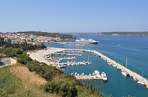
The narrow island of Sphacteria serves as a natural breakwater for Navarino Bay, making the port of Pylos one of the safest anchors of the Ionian coast.
The Paleokastro, located on the top of the promontory of Coryphasium (Koryphasion) (which is in geological continuity with the island of Sphacteria from which it is only separated by the narrow pass of Sykia), is built on the site of the ancient acropolis of Pylos.
They are built mainly between narrow streets, generally symmetrical, and according to the original urban plan established by French military engineers of the Morea expedition at the beginning of the 19th century.
The institute is in charge of the international research project NESTOR and its underwater neutrino detector, which is installed more than 4,000 meters deep, in the deepest marine trench of the Mediterranean Sea, 31 km off Pylos.
Also built by French troops of the Morea expedition in 1829, the central square of Pylos is characterized by its triangular geometric pattern, one of the sides of which opens onto the sea and the port of Pylos, and whose two other sides are bordered by covered galleries with arcades, built with a succession of contiguous arches, each supported by a colonnade, recalling the architecture of the central squares of the bastides of Southwest France and those of the cities of the Ionian Islands (such as Corfu).
In the center, surrounded by two majestic phoenix, is a monument commemorating the battle of Navarino, an obelisk dedicated to the victory of the Allied fleets and their three admirals, the British Edward Codrington, the French Henri de Rigny and the Russian Lodewijk van Heiden.
In addition to the large storage jars and other ceramics from the palace warehouses, there are some wall frescoes, such as that depicting a lyre player with a bird, as well as war and hunting scenes.
In the last room are exposed other finds from the hill of Englianos and the Palace of Nestor and in particular part of the contents of the tombs of this region, such as giant vases, cups and jewelry.
With a depth, at its deepest point, of no more than four meters, its pond constitutes an ornithological reserve of exceptional importance in Europe, as it is the southernmost stopover of birds migrating between the Balkans and Africa.
It gives shelter to no fewer than 270 bird species, among them greater flamingos, glossy ibis, grey herons, great egrets, little egrets, Eurasian curlews, golden plovers, black-winged stilts, great cormorants, common kingfishers, ruffs, garganeys, but also Audouin's gulls and birds of prey (lesser kestrels, ospreys, peregrine falcons and imperial eagles).
The observation post of the Greek Ornithological Society allows visitors to find out more and to watch the shallow brackish waters of the lake; they can walk the paths that circumscribe Gialova's different ecosystems.
[65] Spread over a period of several days, the celebrations culminate on the anniversary of the battle in the port of Pylos, with the participation of the Hellenic Navy and diplomatic and military representatives of the three Allied countries.
Frigates of the Hellenic, British, French and Russian navies, as well as many old sailing ships take part in the reenactment of the famous battle organized with an impressive sound and light show.