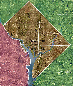
Quadrants of Washington, D.C.
Washington, D.C., is administratively divided into four geographical quadrants of unequal size, each delineated by their ordinal directions from the medallion located in the Crypt under the Rotunda of the Capitol.
[clarification needed] Originally, the District of Columbia was a near-perfect square but contained more than one settlement; the Capitol was to be the center of the City of Washington.
(The geographic center was located near the onetime marshy area of the present-day intersection of 17th Street, NW and Constitution Ave.) As a result, the quadrants are of greatly varying size.
The axis of the National Mall through the Washington Monument and the Lincoln Memorial forms the boundary running west of the medallion.
Many people mistakenly (or in some instances, pejoratively) call the entire eastern portion of the quadrant Anacostia, although the name refers only to a small area along Martin Luther King Jr. Avenue.