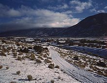
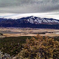
Questa, New Mexico
[citation needed] Questa is on the Enchanted Circle Scenic Byway, near the confluence of the Rio Grande and the Red River.
The Columbine Hondo Wilderness and Latir Peak Wildness are in the Carson National Forest close to Questa.
According to the United States Census Bureau, the village has a total area of 5.1 square miles (13 km2), all land.
The village is a regional hub for the smaller outlying communities of Lama, Cerro, Sunshine Valley, Latir, Costilla, and Amalia.
[5] The Oshara tradition dated to about 3000 BCE is the first known archaeological evidence of Native American (Indians) residence near Questa.
In that year, Governor Diego de Vargas led an expedition northward from Santa Fe in search of food for the destitute Spanish colony.
Vargas confiscated grain from several Pueblo villages, but on arriving in Taos, decided to return to Santa Fe via a roundabout route northward to avoid conflict with the Puebloans.
Vargas and his expedition of 100 men passed by the future site of Questa along the "Rio Colorado" (Red River of New Mexico).
Concerned about encroachments by French and American fur trappers and traders, the Spaniards established a short-lived military post at the Rio Colorado in about 1815.
In 1817, the military in Rio Colorado refused entry into New Mexico and arrested French/American traders Auguste Pierre Chouteau and Jules de Mun and confiscated their goods.
Large grants of land were made to prospective settlers in 1836 and 1841 and the town of San Antonio del Rio Colorado was legally established in 1842.
The location of the village astride ancient trade, raiding, and hunting routes, made resource-based conflict between cultures inevitable.
Additionally, the village location blocked access to certain historic clay and pigment quarries of ceremonial importance to the Taos tribe.
Spanish, Mexican, and eventually American soldiers detailed to defend the beleaguered settlement frequently expressed great frustration with their posting.
The village, nearly from the beginning, was of mixed blood; the surnames Lafore or Laforet, Ledoux, and LaCome reflect the names of French or French-Canadian trappers who settled in the area after arriving in search of otter and beaver.
New Mexico territory license records list Auguste Lacome as residing in the area as a trader with the surrounding Native Americans.
undergoing restoration to improve trout habitat, with the section parallel to Eagle Rock Lake complete.
[16] Economic conditions that affect the mine resulted in a 54 percent cut in personnel in February 2009, which primarily impacted the residents of Questa.
Agriculture in Questa is strongly dependent on irrigation, supplied from the Red River and Cabresto Creek.
Increasingly, the traditional economy based on agriculture, livestock, handicrafts (particularly wooden religious carvings known as santos), wood gathering, and honey is failing to meet the financial needs of the populace of Questa.
With the Historic San Antonio del Rio Colorado Church, Rio Grande del Norte National Monument, Eagle Rock Lake, and the Carson National Forest several avenues for tourism based economic opportunities have taken shape and continue to grow based on the previous and to be expanded tourist activities.
State Highway 38 connects Questa to Red River and Eagle Nest as part of the Enchanted Circle.