Rabati Malik
It was constructed along the Silk Road according to the orders of Karakhanid Shams al-Mulk Nasr, son of Tamgachkhan Ibragim, who ruled in Samarkand from 1068 until 1080.
The arch concludes with the Russian word П-shaped frame, executed from carved terracotta in the form of eight final stars connected with each other, limited by intertwining tapes.
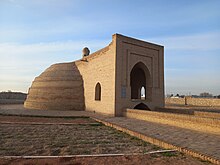
The average height of the kept walls ranges from 0.4 up to 0.7 m. Rabat consisted of a large yard (22.5 × 22.5 m) surrounded by two-storey buildings, supplied with water through ceramic pipes.
[2] The tradition of enclosing caravanserai, palaces and temples with two rows of walls has been preserved in the architecture of Central Asia since the Bronze Age.
The large, brick semi-columns were connected at the top by arches—a rare façade decor found on the flanking walls of the 2500-year-old Apadana palace at Persepolis, and at such Parthian and Sasanian monuments such as Firuzabad.
Regrettably, except for the entrance portal that was badly damaged, the earthquake of 1968 totally demolished what was left of the rest of the rabat,[dubious – discuss] including the landmark flanking walls with the semi-column decorations.
The political history of the region of XI-XII centuries, was associated with the three Turkic Empires and dynasties of the Karakhanids, Ghaznavids and Seljukids, who ruled here with varying success and change of state borders throughout this time.
In the 40s of the 20th century, the facing of the corrugated main facade was dismantled for bricks, the crude base of which was quickly eroded, and in the 1950s, during the construction of Navoiy city, an asphalt road was laid right in the middle of the inner part of Rabat-i Malik.
Umnyakov's research includes a series of historical details about Rabati Malik and highlights the challenges in studying the architecture of the Khorezmshah era.
[4] As a result of these studies, information about the history of Rabati Malik, the time of its construction, architectural features of the internal parts, and numerous artifacts (ceramics, metal, and decorations, including valuables and coins from various years) were found.
Beneath the surface layer of the earth, the remains of square-shaped walls, typical of palace structures, were discovered, along with numerous fragments of schematic drawings.
[6] In the 1950s of the 20th century, the central part of Rabati Malik caravanserai and its cistern was demolished to make way for an asphalt road (M-37), leading to the loss of the urban fabric of the area.