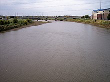
Raccoon River
The river runs through an intensely cultivated area of croplands and livestock farming, receiving Tile drainage from slow-draining rich natural bottomland.
The Racoon River was first documented on the 1814 map by Lewis and Clark, though the USGS references the name to a later map from 1843 named Hydrological Basin of the Upper Mississippi River based on field measurements by Joseph N. Nicollet during his Midwestern expeditions in the 1830s.
[6] The north and south forks join in Dallas County just west of Van Meter, and the Raccoon River flows generally eastward into Polk County, past Walnut Woods State Park and West Des Moines.
On November 20, 2014, nitrates spiked at 13.7 parts per million (ppm), making the water unsafe for pregnant women and infants.
(The US Environmental Protection Agency requires officials to inform the public about safety risks at 10 ppm.)