Rattlesnake Hills
[4] The highest point in the hills (as well as Benton County) is the 3,629 feet (1,106 m) Lookout Summit, which surpasses the more well-known Rattlesnake Mountain by approximately 100 ft (30 m).
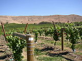
United States Alcohol and Tobacco Tax and Trade Bureau (TTB) awarded Rattlesnake Hills its appellation status on March 20, 2006, making Rattlesnake Hills Washington's ninth federally recognized American Viticultural Area.
[10] The fire was the third in recent years to affect the area surrounding the Hanford Reach National Monument and the Arid Lands Ecology Reserve near Rattlesnake Ridge.
[12][13] As of January 21, 2018, a large but slow landslide is occurring in the Rattlesnake Hills, about 3 miles south of Yakima in Washington, USA.
The Washington State Department of Natural Resources has a web-page providing information on the event, which reports that the moving mass of basalt is about 4 million tons, covering about 20 acres, and it is slipping roughly south at a rate of about 1.5 feet per week.
[15] On the weekend of January 20–21, 2018 there was flurry of new reporting, which highlighted a developing consensus that the landslide will at some time collapse suddenly, and that is likely to occur within months if not weeks.