Yakima Fold Belt

The northernmost fold seen here[5] (Frenchman Hills) ends at the Potholes Reservoir, another (Saddle Mountains) terminates just south of there, near the town of Othello (red circle).

South of the Tri-Cities the rampart of the Horse Heaven Hills extends for a short distance past the Columbia River.

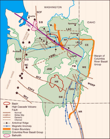
It is the central portion of the Olympic–Wallowa Lineament, referred to as the Cle Elum-Wallula deformed zone (CLEW),[6] constising of a series of generally east-trending narrow asymmetrical anticlinal ridges and broad synclinal valleys formed by folding of Miocene Columbia River basalt flows and sediments.

[9] A graben underlies nearly the entire Yakima Fold Belt and has been subsiding since Eocene time, and continues to sink at a slow rate.

[10] A 2011 report found aeromagnetic, gravity, and paleoseismic evidence that the Yakima Fold Belt is linked to active Puget Sound faults.

Lake Keechelus Lake Kachess Lake Cle Elum Cle Elum Ellensburg Quincy Ephrata Moses Lake Pot Holes Reservoir Othello Yakima Union Gap Wallula Gap Goldendale The Dalles Hood River Tacoma Tri-Cities Mount Rainier Mount St. Helens Mount Adams Rock Island Dam Wanapum Dam Priest Rapids Dam Ice Harbor Dam McNary Dam John Day Dam The Dalles Dam Bonneville Dam White River Cle Elum Ridge South Cle Elum Ridge Manastash Ridge Umtanum Ridge Boylston Mountains Badger Mountain Beezley Hills Saddle Mountains Frenchman Hills Gable Mountain Cleman Mountain Yakima Ridge Bethel Ridge Cowiche Mountain #Sedge Ridge Ahtanum Ridge Rattlesnake Hills Toppenish Ridge Snipes Mountain Horse Heaven Hills #Simcoe Mountain #Bickleton Ridge Columbia Hills (Washington) #Paterson Ridge #Red Mountain Olympic–Wallowa Lineament #craton edge #Naneum-Hog Ranch Anticline
Shaded-relief map showing ridges of the Yakima Fold Belt of south-central Washington , mostly between Interstate 90 (red line) and the Columbia River (bottom). Red square in center is the city of Yakima , red rectangle at lower right is the Tri-Cities , red circles are various cities, triangles are the Mount Rainier , Mount St. Helens , and Mount Adams volcanoes of the Southern Washington Cascades. Purple dashed line marks the approximate location of the Olympic–Wallowa Lineament (OWL), crossing the Columbia River at the Wallula Gap (lower-right). Orange dashed line is approximate location of edge of the North American craton . The smoothness of the central and eastern areas is due to infilling by volcanic flows of the Columbia River Basalts .
Yakima Fold Belt (thin purple lines with black diamonds) in context of major regional geological structures. Pale green is extent of the Columbia River Basalts. Thickest purple line is the OWL, thickest orange line corresponds to the craton edge in the shaded-relief map above. The Klamath-Blue Mountain Lineament (KBML, approximate location, extends to coast) is the southern edge of the marine basalts of Siletzia . BFZ, EDFZ, and MFZ are the Brothers, Eugene-Denio, and McLaughlin fault zones.