Reculver
Reculver once occupied a strategic location at the north-western end of the Wantsum Channel, a sea lane that separated the Isle of Thanet and the Kent mainland until the late Middle Ages.
The earliest recorded form of the name, Regulbium, is in Latin and dates from the early 5th century or before, but it had its origin in a Common Brittonic word meaning "at the promontory" or "great headland".
[5] Stone Age flint tools have been washed out from the cliffs to the west of Reculver,[6] and a Mesolithic tranchet axe was found near the centre of the Roman fort in 1960.
[19] By the 7th century Reculver was part of a landed estate of the Anglo-Saxon kings of Kent, possibly with a royal toll-station or a "significant coastal trading settlement,"[43] given the types and large quantity of coins found there.
[43][Fn 9] Other early Anglo-Saxon finds include a fragment of a gilt bronze brooch, or fibula, which was originally circular and set with coloured stones or glass, a claw beaker and pottery.
[44][Fn 10] Antiquarians such as the 18th-century clergyman John Duncombe believed that King Æthelberht of Kent moved his royal court there from Canterbury in about 597, and built a palace on the site of the Roman ruins.
[47][Fn 11] A church was built on the site of the Roman fort in about 669, when King Ecgberht of Kent granted land for the foundation of a monastery, which was dedicated to St Mary.
[50] The monastery developed as the centre of a "large estate, a manor and a parish",[51] and, by the early 9th century, it had become "extremely wealthy",[52] but it then fell under the control of the archbishops of Canterbury.
[63][Fn 14] In the 13th century Reculver was a parish of "exceptional wealth",[65] and the considerable enlargement of the church building during the Middle Ages indicates that the settlement had become a "thriving township",[51] with "dozens of houses".
[71][Fn 17] The thriving medieval township depended partly on its position on a maritime trade route through the Wantsum Channel, already present in Anglo-Saxon times and exemplified by Reculver's membership of the Cinque Port of Sandwich later in the Middle Ages.
"[94][Fn 21] [At about this time,] from the present shore as far as a place called the Black Rock, seen at lowwater mark, where tradition says, a parish church once stood, there [were] found quantities of tiles, bricks, fragments of walls, tesselated pavements, and other marks of a ruinated town, and the household furniture, dress, and equipment of the horses belonging to the inhabitants of it, [were] continually found among the sands ...In September 1804 a high tide and strong winds led to the destruction of five houses, one of which was "an ancient building, immediately opposite the public house, and had the appearance of having been part of some monastic erection".
[102][Fn 24] Trinity House intervened to ensure that the towers were preserved as a navigational aid, and in 1810 it bought what was left of the structure for £100 and built the first groynes, designed to protect the cliff on which the ruined church stands.
[134] This bomb was used by the RAF's 617 Squadron in Operation Chastise, otherwise known as the Dambuster raids, in which dams in the Ruhr district of Germany were attacked on the night of 16–17 May 1943 by formations of Lancaster bombers.
[137] Part of an inert Upkeep bomb, consisting mostly of a circular end with some of its filling still adhering, was uncovered during beach maintenance work undertaken at Reculver by the Environment Agency on 29 March 2017.
[159] Reculver is in an electoral ward of the same name that includes Beltinge, Bishopstone, Brook Farm, Boyden Gate, Chislet, Hillborough, Hoath and Maypole.
[191] Like other limbs at Fordwich, Deal, Sarre and Stonar, it was then involved in maritime trade, and it shared in the Cinque Ports' duty to supply ships and men for the king's use, in return for concessions such as tax exemption.
[211] The nearest general practitioner (GP) surgery is about 1.4 miles (2.3 km) to the south-west, between Bishopstone and Hillborough, with others in Beltinge, Herne Bay, Broomfield and St Nicholas-at-Wade.
[129][Fn 45] A byname for the towers is the "Twin Sisters", and an account of how this first arose was current about a hundred years after its supposed happening in the late 15th century, but in its usual form, for example in a 19th-century travel guide,[231] it is mostly an invention created around "pseudo-historical detail".
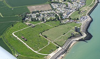
[236] It covers 64 acres (26 ha) and comprises a narrow strip of protected, cliff-top land about 1.5 miles (2 km) long, running from the remaining enclosure of the Roman fort west to Bishopstone Glen.
[241] Canterbury City Council's Reculver Masterplan envisages purchasing farmland to the south of the country park to replace land lost to the sea through coastal erosion.
[242] In 2011 it was found that the shoreline in the Herne Bay area, including Reculver, had come under threat from an invasive species, the carpet sea squirt (Didemnum vexillum), also known as "marine vomit".
[253][Fn 51] Remains of a Roman road leading to the east gate of the fort have also been found, which were "substantial ... consisting of a sandstone platform [10–13 feet (3–4 m)] wide and at least [11 inches (30 cm)] deep.
"[254] In 1817 the nearest access to transport by coach was at Upstreet, about 4 miles (6.4 km) south of Reculver, which lay on a route that ran between London, Canterbury and the Isle of Thanet.
[255] In 1839 coaches and vans ran daily from Herne Bay to Canterbury and on to destinations on the southern and eastern coasts of Kent, with access to the English Channel, at Deal, Dover, Sandgate and Hythe.
[257] Today, bus services calling at a stop adjacent to the King Ethelbert Inn connect Reculver with Herne Bay, Canterbury, Birchington and Margate.
[20] The quantity and variety of coins found at Reculver dating from the 7th century to the 8th are almost certainly related to its location on a major trade route through the Wantsum Channel;[43] there was probably still a harbour in Anglo-Saxon times, and the monastery may well have operated a "fleet of ships and its own boatyard.
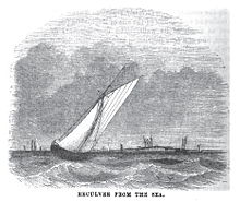
[271][Fn 52] Passenger steamships called at Herne Bay pier on their route between London and destinations along the north coast of Kent from 1832, but this service ceased in the first half of the 20th century.
[301] He had sold all of his possessions in Kent by 1574 to "finance his extravagance",[301] and Brook subsequently became the property of Sir Cavalliero Maycote, who was a leading courtier to Elizabeth I and James I.
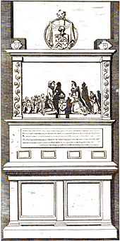
[295] He had a "handsome monument [on the south wall of the chancel in the church at Reculver] representing Sir Cavalliero and Lady Maycote, with their nine children, all in alabaster figures, kneeling".
[313][Fn 62] Robert Hunt, vicar of Reculver from 1595 to 1602, became minister of religion to the English colonial settlement at Jamestown, Virginia, sailing there in the ship Susan Constant in 1606, and celebrated probably "the first known service of holy communion in what is today the United States of America on 21 June 1607.