Red Castle of Tripoli
In the 1970s, the building of the seafront highway (Al-Shat Road) resulted in the creation of the Saraya Lake, as the castle was cut off from the sea.
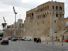
The building is bordered by the Saraya Lake to the northeast, the Central Bank of Libya to the northwest, the Souq al-Mushir neighborhood around the Karamanli Mosque to the southwest, and Martyrs' Square to the southeast.
The origins of the castle may be as old as the Phoenician foundation of Oea in the 7th century BCE; excavations have found remains dating back to Roman times.
Much of the current structures appear to date from the subsequent period of rule by Aragonese military commanders and, after 1530, by the Knights Hospitaller until their expulsion by the Ottoman Empire following the Siege of Tripoli (1551).
Brasini modified the Saint George Bastion to a more medieval appearance,[7] created a new (albeit ancient-looking) entrance portal, and built the castle's iconic arches above the eastern (Saint James) bastion, originally facing the sea and now on the Saraya Lake.