Reference marker
This was initiated in response to the Highway Safety Act of 1966[1][failed verification] enacted by Congress, in an effort to monitor traffic and identify high-accident locations.
New York's system inventories and indexes all touring and reference routes, in addition to service and rest areas, ramps, and reservation roads.
The reference markers (popularly referred to as "little green signs", or "tenth-mile markers") are typically-green signs that measure 8 inches (200 mm) wide by 10 inches (252 mm) high and are placed every 528 feet (161 m) on state roads, freeways, and parkways.
When two or more routes run concurrently or overlap, typically only the lower number highway will be present, while in some cases, a higher level highway's number appears instead, such as "88I" appearing on markers where NY 28 overlaps Interstate 88 near Oneonta.
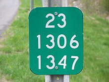
[3] Outside of New York City, the third and fourth digits of the second row indicate the number of counties the route has entered, starting at "01".
[4] The first digit of the bottom row is the control segment, which starts at 1 at the county line or route's terminus.
The last three digits of the bottom row represent approximate distance in tenths of a mile from the beginning of the last control segment or county line.
If an intersection, impermeable material, or other obstruction exists, a marker may be placed nearby but in violation of the above tolerance, on the opposite side of the road on which it would otherwise be placed, or missing altogether.
When a route is split onto two city streets, each one-way for the specific direction of travel, the northbound or eastbound markers are unchanged.
Both the southbound and westbound segments of both routes, maintained by NYSDOT, carry the "V" designation.
The second is the letter "A" through "M", ordered counterclockwise starting with the higher level route's ramp oriented west–east or south–north, and is subject to interpretation.
The last two digits are the same sequencing number; if they exceed 9.9 miles (15.9 km), then the preceding letter will be incremented.
The second row will have the same county designation, with the third and fourth digits being a sequence the same as a service road.
The third row will begin with: 1, Reservations or Department of Health; 2, Military and Naval Affairs; 3, Education; 4, State Police; 5, Executive-Youth; 6, Conservation; 7, Corrections; 8, Social Services; 9, Mental Hygiene; O, Other.
Originally, reference markers were on square 8-inch (200 mm) signs and the numbers were not reflective.
In many areas of the state, older markers are still present or are used in combination with newer, reflective ones.