List of regions of Canada
Seats in the Senate are equally divided among four regions: the West, Ontario, Quebec, and the Maritimes, with special status for Newfoundland and Labrador as well as for the three territories of Northern Canada ('the North').
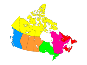
[1] Immigration, Refugees and Citizenship Canada uses the five-region model, while seven regions are commonly used for polling.
In some cases, the primary regions are separated by identifiable transition zones, particularly in Alberta, Saskatchewan, and Ontario.
In other large provinces, the primary and secondary geographic regions are defined more strictly by topographical and ecological boundaries.
British Columbia has a much greater number of local regions and sub-regions than the other provinces and territories due to its mountainous terrain where almost every populated lake, sound, and river valley, and every populated cape and cluster of small islands can claim a distinct geographical identity.
At the other extreme, Prince Edward Island is not divided into any widely recognized geographic regions or sub-regions because of its very small size and lack of large rivers or rugged terrain.