Relleu
Relleu borders the municipalities of Aigües, Alicante/Alacant, Busot, Jijona/Xixona, Orxeta, Penàguila, Sella and Torremanzanas/La Torre de les Maçanes.
It was brought into focus by Doctor Alejandro Sendra, who found, on his property, the burial stone of ‘Paccius’ that indicated Roman occupation well inside the Imperium.
The history of Relleu precedes the Romans by at least four centuries as there was an Iberian settlement within the Parish boundaries a little distance from the town on the highest point of the Penya-roja (Spanish Peñarroja).
This material, together with other artefacts deposited in the local museum, with similar characteristics to those found in the settlement give the impression of permanent occupation more or less through the 2nd and 1st centuries BC when Romans controlled the area.
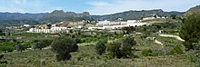
Relleu (which means "relief" in Valencian) owes its name to the rugged terrain that makes up the municipality and is overlooked by the ruins of an 11th-century castle built by the Muslim population.
After the conquest of the region by the troops of James I of Aragon Relleu would become the property of Bernat de Sarrià depending ecclesiastically on Finestrat parish until 1535.
In recent years Relleu has become an attractive destination for (mainly) British citizens, which has reversed the depopulation, so that in 2011 it had 1,338 inhabitants of which 42.1% were of foreign nationality, however, by 2018 the figure had fallen to 38.3%.
Although agriculture (mainly almonds and olives) is still in practice, it is not as important as it was in the last century and today the economic source of Relleu depends mostly on the services sector.
This equates to 23 cars per inhabitant making it the municipality with the largest number of registered vehicles per capita in Spain.
The militia chief put a gun to the mayor's chest and ordered him to have the bells ready for collection in two weeks' time.
The dam was built at the instigation of the inhabitants of Villajoyosa, who received a document in 1653 from King Philip IV authorizing its construction.
On the road to Torremanzanas, near the village water supply, is one of just a few places where one can see evidence of the K-T Boundary, this is a geological mark left by an asteroid that struck the earth causing the K–T extinction event which killed the dinosaurs.
Plus the various "coques" (sweet or savoury bread based cakes) named "Farcida", "Escaldà", or "a la Paleta".