History of tornado research
It covers the entire, 33 km (18.6 mi) long track and also includes eyewitness reports as well as an analysis of the debris and hail fallout areas.
[10] In May 1820 Józef Karol Skrodzki, Professor at the University of Warsaw, read a paper describing a tornado that occurred in Mazew, Łęczyca County in Poland on August 10, 1819.
The path was surveyed by many scientists on account of its location between New York City and Philadelphia, including early tornado theorists James Pollard Espy and William Charles Redfield.
A conclusion that remains accurate today is that the most intense damage tends to be on right side of a tornado (with respect to direction of forward movement), which was found to be generally easterly).
[18] In 1865, the first in India and earliest known scientific survey of a tornado that analyzed structure and dynamics was published in 1865 by Indian scientist Chunder Sikur Chatterjee.
The path damage survey of a tornado that occurred at Pundooah (now Pandua), Hugli district, West Bengal, India, was documented on maps and revealed multiple vortices, the tornadocyclone, and direction of rotation,[19] predating work by John Park Finley, Alfred Wegener, Johannes Letzmann, and Ted Fujita.
[25] Also in 1896, Norman B. Conger, an inspector with the United States Weather Bureau, conducted and published a case study on the 1896 Thomas, Michigan tornado, based on "all reliable, available sources".
[27] In July 1897, M. C. Walsh with the La Salle Institute reported the beginning of the 1896 St. Louis–East St. Louis tornado's track, which included a description of "two long, heavy black masses of cloud, one moving from the southwest, the other curving from the northeast" with them meeting "at a height of about 1,000 feet (330 yd; 300 m)".
[28] In February 1898, J. J. O'Donnell, an observer for the United States Weather Bureau, published a detailed meteorological case study and damage analysis on a violent tornado which struck Fort Smith, Arkansas, on January 11-12, 1898.
Cleveland Abbe responded by saying "it is certain that if any such arrangement were possible, the Weather Bureau would have done this many years ago" along with "we must remember that the destructive areas of tornadoes, and even of thunderstorms, are so small that the chance of being injured is exceedingly slight" and that "we do not attempt to prevent that which is inevitable".
Cleveland Abbe added on to the publication by Widmeyer saying, "It is unnecessary to resort to the caves and cellars, or to stop our ordinary avocations for fear of a tornado, until we see the cloud in the distance, or are positively certain that one is about to pass near us".
[40] In 1901 and later again in 1906, Frank H. Bigelow, chief of the United States Weather Bureau, calculated and published formulas to find the rotational speed of a tornado based on the height above sea level.
[41][42] Bigelow's formula went on to help Alfred Wegener, a leading geophysicist, atmospheric scientist, and an Arctic explorer, develop the hypothesis that tornadoes can form off of a gust front.
[43] In May 1902, S. C. Emery with the United States Weather Bureau published a case study and damage survey for a 118 mi (190 km)-long tornado which struck northeastern Mississippi and northwestern Alabama on March 28, 1902.
Hunt, an Australian Government meteorologist, published a case study on a destructive tornado which sturck North Sydney, New South Wales, Australia, on March 27, 1906.
Pate later would describe the Montgomery–Chisholm tornado as "the most officially observed one in history", as it passed 2 miles (3.2 km) away from four different government weather stations, including the U.S.
[80] In October, Matthew R. Clark with the United Kingdom's Met Office published a case study on a tornadic storm in southern England on December 30, 2006.
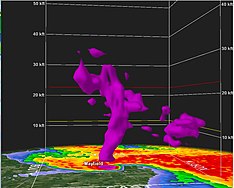
[88] The University of Oklahoma's RaXPol mobile Doppler weather radar, positioned at a nearby overpass, measured winds preliminarily analyzed as in excess of 296 mph (476 km/h).
[94] During the same month, researchers at Lyndon State College and the University of Colorado Boulder published a damage and radar analysis of the 2013 Moore tornado.
The project involved over a hundred people from sixteen organizations and was described as "the largest and most ambitious study focused on improving [the] understanding of tornadoes associated with linear storms."
[114] In January 2024, researchers with Colorado State University’s Department of Atmospheric Science, published an analysis and database of 74 tornadoes which occurred in South America.
[118] On February 8, meteorologist and storm chaser Reed Timmer, along with Mark Simpson, Sean Schofer, Curtis Brooks, published a paper about the design of and information about a new meteorological rocket probe which can be launched into tornadoes.
In their conclusion, the researchers also posed the question: "Does a 0–5 ranking scale make sense given the current state of understanding of the low-level tornado wind profile and engineering of structures?
[122] Also in April, Timothy A. Coleman, with the University of Alabama in Huntsville (UAH), Richard L. Thompson with the NOAA Storm Prediction Center, and Dr. Gregory S. Forbes, a retired meteorologist from The Weather Channel published an article to the Journal of Applied Meteorology and Climatology stating, "it is apparent that the perceived shift in tornado activity from the traditional tornado alley in the Great Plains to the eastern U.S. is indeed real".
[123][124] On April 26, a Doppler on Wheels (DOW) mobile radar truck measured 1-second wind speeds of approximately 224 mph (360 km/h) at a height of ~282 yards (258 m) as a tornado passed near Harlan, Iowa, causing widespread destruction.
At the end of the analysis, the researchers stated, "the lofting wind speeds given by this model are much higher than the rating based on the ground survey EF-scale assessment.
[142] Also in July, Jennifer M. First with the University of Missouri, published a paper examining the aftermath of the 2020 Nashville tornado, focusing on the mental health issues of survivors and the gender-based recovery difference.
[147] On July 30, Andrew Mercer, Kenneth Swan, and Adonte Knight with Mississippi State University published the first quantitative definition for how to define a tornado outbreak.
[148] In August 2024, Jordan Tweedie with the University of Oklahoma, published a paper on how the lower atmospheric boundary layer affected the supercell which produced the violent 2023 Rolling Fork–Silver City EF4 tornado.
In their study, the researchers published about how the Atmospheric Remote Sensing Observatory (CARO), located 10 km (6.2 mi) away from the tornado in the city of Limassol, recorded a vertical wind speed of 10 m/s (22 mph) as well as an instantaneous rate of rain from the storm of 90 millimetres per hour (3.5 in/h).