Reverie, Tennessee
[4] In the first half of the 20th century, archeological artifacts from an aboriginal village dated AD 1400-1650 were found about 4 miles (6.4 km) northeast of Reverie, at the Nodena site.
Modern machines such as the cotton picker have made the manual cultivation obsolete over time as they took over the work from the hand laborers.
As a result of the lessened need for agricultural laborers, and very little potential for other forms of employment, the population of the area has dropped precipitously in recent decades.
[4] About 4 mi (6.4 km) northeast of Reverie, at the Nodena site, artifacts from a 15 acre (6.1 hectare) aboriginal village dated AD 1400-1650 were found in the first half of the 20th century.
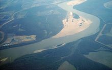
After the avulsion of 1876, the Mississippi River ran southeast of Reverie, cutting it off from Tipton County.
Today, Reverie is surrounded by the modern Mississippi River in the southeast and the sidearms following the 1795 course in the northwest.
[15][16] The direct distance between Reverie and the county seat, Covington, Tennessee, is only 18 miles (29 km).
As of 2007, the road trip to Covington required the driver to go via Memphis, Tennessee and was longer than 83 miles.
In 2007, the Mississippi River was located about 3.5 miles (5,6 km) southeast of the Tennessee/Arkansas state border near Reverie.