Rheinfelden (Aargau)
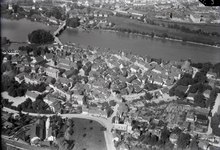
The old town of Rheinfelden lies on the left bank of the Rhine, where the river is divided into two arms by the "Inseli", a roughly 150 metres (490 ft) long island.
Downstream of the Inseli and the Rheinbrücke, the river bottoms drops to about 30 m (98 ft) deep, creating a huge and deadly vortex, known as the St-Anna-Loch.
Neighbouring cities are Kaiseraugst to the west, Olsberg to the south-west, Magden to the south and Möhlin to the east (all in the Aargau); over the river in Germany lies Rheinfelden, Baden-Württemberg.
In the year 45 BC, a few kilometres further west, the settlement Augusta Raurica was founded, the first Roman town in Switzerland, near modern Kaiseraugst.
The Rheinfeldens built a fortress, "Stein", on the strategically located island; a riverbank settlement stood at the "Altenburg".
The last of this comital line was Rudolf of Rheinfelden, Duke of Swabia (1057–79) and German antiking (1077–80) during the Investiture Controversy.
When Rudolf died on 15 October 1080 in Merseburg, his territories were inherited by Berthold II of Zähringen.but the town went to his son Otto and his family the von Wetter's.
In 1445, when the Habsburgs were fighting the Old Zürich War, insurgents destroyed the castle on the "Inseli", due to the city's allegiance with Basel.
On 28 February the Battle of Rheinfelden began, as the city was attacked by numerically superior Imperial and Bavarian troops under the command of Johann von Werth and Federico Savelli.
Bernhard brought them weapons, but in the second action, on 3 March, they were victorious, as he and his men unexpectedly re-appeared on the battlefield; both Savelli and Werth were captured.
By the end of the Thirty Years' War, the Austrians had built a fortress on the island to secure the southwestern border of the Breisgau.
In 1745, during the War of the Austrian Succession, the French made a fortress on the same ground and also blasted a portion of the city wall.
On 20 February 1802 Rheinfelden was made a district capital of the newly created Canton of Fricktal, (Principality of Frickgau), joining the Helvetic Republic in August, the point at which the city became decisively Swiss.
After the removal of the governor Sebastian Fahrländer at the end of September 1802, the seat of the cantonal government was relocated here from Laufenburg.
With the Reichsdeputationshauptschluss, the remaining (German) parts of the city lost their independence to the Grand Duchy of Baden, becoming Rheinfelden, Germany.
[14] The historical population is given in the following table:[8] The entire old town of Rheinfelden is designated as part of the Inventory of Swiss Heritage Sites.
[16] Two religious buildings are on the list, the Christian Catholic collegiate church of St. Martin and the Johanniter Chapel at Johannitergasse 70.
Three fortifications are on the list; the Heimenholz and the Pferrichgraben which were both part of the old Roman era Rhine fortications and the entire medieval city wall.
The last two buildings on the list are the Feldschlösschen brewery at Feldschlösschenstrasse 34 and the former Gasthof (combination hotel and restaurant) zum goldenen Adler at Obertorplatz 4.