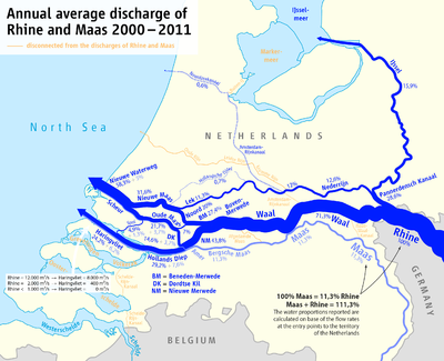
Rhine–Meuse–Scheldt delta
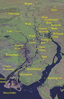
The result is a multitude of islands, branches and branch names, in which a waterway that appears to be one continuous stream may have numerous separate names for different sections, e.g. Rhine → Bijlands Kanaal → Pannerdens Kanaal → Nederrijn → Lek → Nieuwe Maas → Het Scheur → Nieuwe Waterweg.
The delta is the entrance from the North Sea to the German and Central European hinterland (and to a lesser extent France).
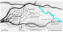
Before the St. Elizabeth's flood (1421) the Meuse flowed just south of today's line Merwede–Oude Maas to the North Sea and formed an archipelago-like estuary with the Waal and the Lek.
This system of numerous bays, estuary-like extended rivers, many islands and constant changes of the coastline, is hard to imagine today.
For flood protection reasons, the Meuse was separated from the Waal through a lock and diverted into a new outlet called the "Bergse Maas", then the Amer flowing into the former bay known as the Hollands Diep.
The northwestern part of the estuary (around Hook of Holland), is still called Maasmond ("Meuse Mouth"), ignoring the fact that it now carries only water from the Rhine.
This meant that high tide formed a serious risk because strong tidal currents could tear huge areas of land into the sea.
Pliny the Elder's Natural History gives a list of tribes living in the "Gaulish islands", within the delta region between different mouths of the Rhine.