River Frome, Bristol
As with many urban rivers, the Frome has suffered from pollution, but several stretches run through parks and reserves that sustain a range of wildlife.
As the city of Bristol developed in the nineteenth and twentieth centuries, flooding became a major problem, remedied by the construction of storm drains and diversions.
[2] 20 miles (32 km) long, the River Frome rises in the grounds of Dodington Park in the Cotswolds of South Gloucestershire, flows through Chipping Sodbury in a northwesterly direction through Yate, and is then joined by the Nibley brook at Nibley and the Mayshill brook at Algars Manor near Iron Acton, both on the left.
Turning in a more southwesterly direction the river enters Oldbury Court estate, a city park also known as Vassal's, where it is joined by the first of two Fishponds brooks both on the left.
The river then flows under the M32 motorway and parallels its course for a while before disappearing into an underground culvert at Eastville Sluices, upstream of Baptist Mills.
The Frome originally joined the Avon somewhere on Welsh Back downstream of Bristol Bridge, and an offshoot formed part of the city defences.
To reduce sewage pollution and silting in the harbour, a new culvert was constructed in 1825 to redirect much of the flow from the Frome into the New Cut of the River Avon.
[6] The original culverted section between Stone Bridge and St Augustine's Reach remains in use as a flood relief channel.
From Damsons Bridge (Grid Reference ST657794) to Snuff Mills (ST623764) the river is navigable, but only by canoe (kayak) though some portaging may be required.
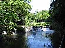
[7] Between Frenchay and Stapleton the river drops nearly 50 feet (15 m), and as a result there a number of corn and other mills were established to harness the water power.
The section of meandering river back to the site of today's culverted Stonebridge was also widened out as part of the new ocean going Frome harbour.
The increasing use of the Frome as an open sewer combined with the loss of the scouring action of the tides meant that it was now becoming a health hazard and in 1828 it was again diverted, with a mitre floodgate at StoneBridge, channelling the main flow through Mylne's Culvert, under the quays and under the bed of the floating harbour at Prince Street Bridge to the emerge in the tidal Avon New Cut, to the east of what is now Gaol Ferry Bridge, locally known as God's Garden in the 21st century.
[17] In December 2011, a kayaker was killed after capsizing in the flooded river at Snuff Mills weir in Frenchay during a night-time paddle.
[18][19] The Frome Valley Walkway is a public footpath, 18 miles (29 km) long, that runs almost the entire length of the river from Old Sodbury to Bristol.