River Trent
[24] During the Pleistocene epoch (1.7 million years ago), the River Trent rose in the Welsh hills and flowed almost east from Nottingham through the present Vale of Belvoir to cut a gap through the limestone ridge at Ancaster and thence to the North Sea.
During a following glaciation (Devensian, 70,000 BC) the ice held back vast areas of water – called Glacial Lake Humber – in the current lower Trent basin.
Intensive arable farming of cereals and root vegetables, chiefly potatoes and sugar beet occurs in the lowland areas, such as the Vale of Belvoir and the lower reaches of the Trent, Torne and Idle.
Whilst this is not unique for an English river, it does mean that there is an ongoing legacy of issues relating to urban runoff, pollution incidents, and effluent dilution from sewage treatment, industry and coal mining.
[36][37] In the wider catchment the geology is more varied, ranging from the Precambrian rocks of the Charnwood Forest, through to the Jurassic limestone that forms the Lincolnshire Edge and the eastern watershed of the Trent.
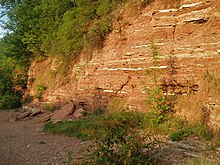
There is thought to be a complex succession of at least six separate gravel terrace systems along the river, deposited when a much larger Trent flowed through the existing valley, and along its ancestral routes through the water gaps at Lincoln and Ancaster.
Contained within these terraces is evidence of the mega fauna that once lived along the river, the bones and teeth of animals such as the woolly mammoth, bison and wolves that existed during colder periods have all been identified.
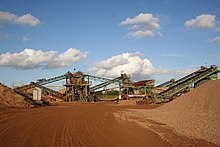
[41] The lower sequences of these terraces have been widely quarried for sand and gravel, and the extraction of these minerals continues to be an important industry in the Trent Valley, with some three million tonnes of aggregates being produced each year.
[46]: 36–47 Four of these main tributaries, including the Dove and Derwent which drain the upland Peak District, all join within the middle reaches, giving rise to a comparatively energetic river system for the UK.
[49] Rainfall totals in the Tame are not as high as would be expected from the moderate relief, due to the rain shadow effect of the Welsh mountains to the west, reducing amounts to an average of 691 mm (27.2 in) for the tributary basin.
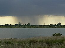
[51][52][53] Like other large lowland British rivers, the Trent is vulnerable to long periods of rainfall caused by sluggish low pressure weather systems repeatedly crossing the basin from the Atlantic, especially during the autumn and winter when evaporation is at its lowest.
The last point of measurement is North Muskham here the average flow is 88.4 m3/s (3,120 cu ft/s), a relatively small increase due to the input of the Devon, and other smaller Nottinghamshire tributaries.
[72] Warp was also used as a commercial product, after being collected from the river banks at low tide, it was transported along the Chesterfield Canal to Walkeringham where it was dried out and refined to be eventually sold as a silver polish for cutlery manufacturers.
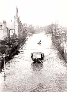
[33][86] In December 2013, the largest storm surge since the 1950s occurred on the Trent, when a high spring tide combined with strong winds and a low pressure weather system, produced elevated tidal river levels in the lower reaches.
[89] In 1748, merchants from Nottingham attempted to end this monopoly by landing goods on the banks and into carts, but Fosbrooke used his ferry rope to block the river, and then created a bridge by mooring boats across the channel, and employing men to defend them.
The cost exceeded the authorised capital by a large margin, with the extra being borrowed, but the company continued to pay a 7 per cent dividend on the original shares and on those created to finance the new work.
[109][110] This divide was also described in Michael Drayton's epic topographical poem, Poly-Olbion, The Sixe and Twentieth Song, 1622: And of the British floods, though but the third I be, Yet Thames and Severne both in this come short of me, For that I am the mere of England, that divides The north part from the south, on my so either sides, that reckoning how these tracts in compasse be extent, Men bound them on the north, or on the south of Trent[111] It is not clear when pollution first became an issue for the River Trent, but in the late 1880s, it had a thriving salmon fishery, with the river producing an annual catch of some 3,000 fish, a decade later, this had fallen to 100.
The tipping point being the introduction of piped water and a basic sewer network, which meant that effluent, which was previously stored in cesspits, was carried away through drains into the nearest brook.
[114] Although he provided land for a sewage works nearby at Strongford, the problems continued such that in 1905 the Levenson-Gower family left Trentham altogether and moved to their other properties, including Dunrobin Castle in Scotland.
[115][118] The pollution of the "Trent catchment was probably at its worst in the late 1950s",[115] this being the result of the ongoing industrialisation of the urban areas, combined with the interruption and under investment caused by two world wars, which lead to only piecemeal improvements of the sewerage treatment infrastructure taking place.
The changes were helped by the introduction of more stringent pollution control legislation, which required industrial waste to be discharged to sewers, and the formation of the Trent River Authority, which had new duties relating to managing water quality issues.
[125] The river remains vulnerable to these pollution events, such as the one that occurred in October 2009 when an accidental release of cyanide from a factory into the sewer system in Stoke-on-Trent, affected the treatment works at Strongford.
[125][129] Artificial changes along the Trent, due to navigation, farming, mineral extraction and drainage works, mean that much of the riparian landscape has been altered, reducing the amount of natural habitat.
A vestige of the saline marshes created by the brine springs that seep from the groundwater of the Mercia mudstones, the reserve contains salt tolerant species normally found on the coast, such as sea plantain, arrowgrass and milkwort.
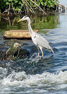
[153] The effluent and industrial pollution of the early 20th century, led to a rapid decline in fish stocks, large stretches of the river became fishless and species such as salmon almost disappeared.
[155] Analysis of catch returns from 1969 to 1985, showed that the fish caught most often by anglers were barbel, bream, bleak, carp, chub, dace, eel, gudgeon, perch, and roach.
Over the study period the returns revealed that there was a variation in the species caught, with a shift from roach and dace based catches, to one of chub and bream, a change that was perceived by anglers to represent a ‘serious detriment’ to the fishery.
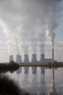
This combined with the nearby supplies of fuel in the form of coal from the Nottinghamshire and Yorkshire coalfields, and the existing railway infrastructure meant that a string of twelve large power stations were originally constructed along its banks.
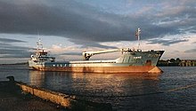
[177] In downstream order, the power stations that have used the river as their source of cooling water are: Meaford, Rugeley, Drakelow, Willington, Castle Donington, Ratcliffe-on-Soar, Wilford, Staythorpe, High Marnham, Cottam, West Burton and Keadby.
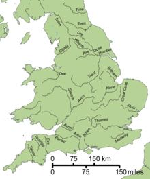
[201] [202] Although Spenser endowed 'The beauteous Trent' with 'thirty different streams'[d] the river is joined by more than twice that number of different tributaries,[204] of which the largest in terms of flow is the Tame which drains most of the West Midlands, including Birmingham and the Black Country.