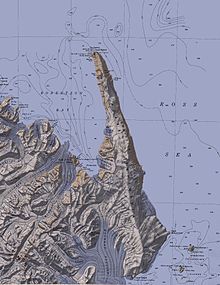
Robertson Bay
Discovered in 1841 by Captain James Clark Ross, Royal Navy, who named it for Dr. John Robertson, surgeon on HMS Terror.
The glacier drains the northern slopes of Mount Adam and flows along the east wall of DuBridge Range to Pressure Bay.
The seaward end of the glacier was first mapped by the Northern Party, led by Victor Campbell, of the British Antarctic Expedition, 1910-13.
Named by Campbell for Sir Arthur Shipley, master of Christ's College, Cambridge, England, at the suggestion of Priestley.
First charted by the British Antarctic Expedition, 1898-1900, under Carsten Egeberg Borchgrevink, who named it for Colonel Haffner, Director of the Government Survey of Norway.
Borchgrevink, who named this feature for Professor Hans Henrik Reusch, then president of the Norwegian Geographical Society.
Named by the United States Advisory Committee on Antarctic Names (US-ACAN) for William R. Crume, AS1, United States Navy, Support Equipment Maintenance Supervisor with Squadron VX-6 at McMurdo Station during Operation Deep Freeze 1968.
A glacier about 25 nautical miles (46 km; 29 mi) long, draining northeast from the Admiralty Mountains into Robertson Bay.
The generic "Land" has been changed to "Ridge," since it was not appropriate for so small a feature, but Borchgrevink's intent in naming the whole mass has been respected.
A valley glacier, 20 nautical miles (37 km; 23 mi) long, draining seaward along the east side of Geikie Ridge in the Admiralty Mountains.
A glacier that drops sharply from the Adare Saddle to empty into Protection Cove at the head of Robertson Bay.
The feature was so named by Borchgrevink because southerly gales at Cape Adare were always heralded by a cloud of snow sweeping over this glacier into Robertson Bay.
The high, northern point of Flat Island, marking the west side of the entrance to Robertson Bay.
James Ross, in January 1840, applied this name to a cape of the mainland, honoring Sir John Barrow, founder of the Royal Geographic Society, 1830, and Secretary of the Admiralty, 1807-45.
The feature was mapped as a point on Flat Island by the British Antarctic Expedition, 1910-13, led by Scott.
A 480 metres (1,570 ft) high flat-topped island, 3 nautical miles (5.6 km; 3.5 mi) long, lying at the terminus of Shipley Glacier.
Its northeast tip, Cape Barrow, marks the west side of the entrance to Robertson Bay.
A small bay formed by the configuration of the ice at the terminus of Shipley Glacier and the northwest side of Flat Island.
Charted by the Northern Party, led by Campbell, of the British Antarctic Expedition, 1910-13, and so named by them because they heard a noise like a ship's siren while mapping this area.
A point marking the east extremity of Flat Island at the western entrance to Robertson Bay.
Discovered in January 1841 by Captain James Ross, Royal Navy, and named by him for Charles Wood, First Secretary to the Admiralty.
An arm of Robertson Bay, 3 nautical miles (5.6 km; 3.5 mi) wide, lying between Cape Wood and Birthday Point.
The Northern Party experienced great difficulty in sledging across the pressure ice fringing the shore of Robertson Bay.
Charted and named in 1911 by the Northern Party led by Victor Campbell of the British Antarctic Expedition, 1910-13, because icebergs appear to gravitate there.
Charted by the Northern Party, led by Campbell, of British Antarctic Expedition, 1910-13, who named it for its shape.
The Nielsen, Ommanney, Crume and Reusch Glaciers flowing into the bay contribute to these pressures.
Named by them after the nickname "Penelope" given to Lieutenant Harry Lewin Lee Pennell, commander of the expedition ship Terra Nova.
A mountainous ice-free island, 2.5 nautical miles (4.6 km; 2.9 mi) long, lying in the south part of Robertson Bay.
A cove between Duke of York Island and Cape Klovstad in the south part of Robertson Bay.
[35] This article incorporates public domain material from websites or documents of the United States Geological Survey.