Rock Creek Trails
The main route extends 22 miles from Lake Needwood in Maryland to the Inlet Bridge in Washington, D.C., with a loop in the north part of Rock Creek Park and other trails through the Klingle Valley, Turkey Branch Valley, and along the North Branch of Rock Creek.
The section along the Potomac River from Arlington Memorial Bridge to Rock Creek is sometimes called the Shoreline Trail.
The experiment was a success at encouraging bike use, but caused traffic jams so the Park Service paved bridle paths immediately to the west of the creek.
At some point prior to 2000, NPS constructed a trail connection on Shoreham Hill to Calvert Street, as recommended by the Park Service's 1990 Plan for Paved Recreational Trails of the National Capitol Region (which also recommended adding a new connection at Massachusetts Ave; bypassing the Zoo Tunnel; widening the bridge south of the Zoo; and improving the ramp crossings at P and Pennsylvania)[7] and paved a small parallel trail through Rose Park in Georgetown.
[25] In March 2021, DDOT began a rehabilitation project on the section of the Parkway Trail from P Street to Shoreham Drive, and to build a new bridge over Rock Creek just south of the Zoo Tunnel.
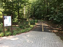
The trail through Rock Creek Park was first constructed in 1971 along a bridle path dating back to the early 20th century.
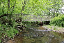
After the September 1971 experimental closing of a lane of the Rock Creek Parkway for the use of cyclists showed the interests of bike commuters, NPS paved a parallel bridle path from Bluff Bridge, built in 1934, to P Street, NW.
[32][33][12] These first sections of trail were 4 to 8 feet wide with rough pavement, steep slopes, poor visibility and sharp curves.
[38] NPS has long sought a way to close the gap between the park trail, the loop and the section in Maryland.
[43] Six months later, under pressure from the American Automobile Association and the governments of DC and Montgomery County, NPS decided not to close the section of Beach.
[7] In 1991, a loosely knit, cyclist-dominated group called "Auto-Free DC" renewed the push to ban automobile traffic on Beach Drive.
When NPS failed to take up their suggestion, the group led a series of "rolling road block" protests which aimed to peaceably draw attention to the cause by disrupting rush hour traffic.
Nonetheless, the protests led to some confrontations and arrests, and at one point the Military Road Bridge was graffitied with anti-automobile slogans.
An additional alternative created by the People's Alliance for Rock Creek (PARC), a group consisting of the Washington Area Bicyclists Association, the Sierra Club, Friends of the Earth and 18 other advocacy groups, suggested making Beach Drive auto-free north of Broad Branch as a means of completing the trail envisioned in 1965.
[46] In 2003, in an attempt to appease both groups, NPS proposed extending the weekend closures of Beach Drive to weekdays from 9:30 am to 3:30 pm.
Within Rock Creek Park, the project would rehabilitate the Zoo Tunnel bypass (or Zoo Loop), a section between Klingle Ford Footbridge and Bluff Bridge called the Western Ridge Trail and a section on the west side of the creek south of Broad Branch Road.
The system started in January 1967 when NPS announced a plan to build a trail from Military Road to the District boundary.
[54] The crushed bluestone trail was constructed from the Nature Center, past Wise Road to a turnaround loop just southwest of Beach Drive and the DC boundary.
[60][56] Over time, the Rock Creek section ceased to be viewed as part of the Fort Circle Trail system.
[64][65][66][67][68] Planning for the trail began in the late 1960s and faced strong opposition from the same groups who had opposed extending Beach Drive in 1968.
[70] Construction began the following year when MNCPPC opened a fly-ash surfaced trail along Beach Drive in Kensington.
From 1975 to 1977 they extended the trail south to East-West Highway and north to Knowles Avenue with four connections to Parkwood, in Rock Creek Stream Valley unit 4, adding another 3.1 miles.
[41] In 1979, MNCPPC began work to extend the trail from Veirs Mill north to Baltimore Road, which was completed by 1981.
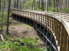
[88][89] On July 23, 2011, Montgomery County Parks and the Maryland State Highway Administration opened the $5.8 million trail bridge over Veirs Mill that had been in planning since at least 2004.
[97] In 2021, Montgomery County began the work of replacing the Beach Drive Bridge over Silver Creek just east of Kensington Parkway.
The first section of the trail north of Muncaster Mill was the 1.6-mile-long Wickham Road Bike Path in Olney which was constructed in 2002.
[101] It connected Laytonsville Road to trails planned along the North Branch as part of the Norbeck Grove development.
[103][104] In 2016–17 a 1.8-mile-long section of trail located north of the ICC on Park and Planning property was constructed as part of the Preserve at Rock Creek project.
It extended the Emory Lane bikepath south to Muncaster Mill and then east to the edge of Rock Creek Regional Park.
[123] The section is 1.4 miles long, crosses the North Branch and runs directly adjacent to Maryland Route 200.