Roman Libya
After the final conquest and destruction of Carthage in 146 BC, northwestern Africa went under Roman rule and, shortly thereafter, the coastal area of what is now western Libya was established as a province under the name of Tripolitania with Leptis Magna capital and the major trading port in the region.
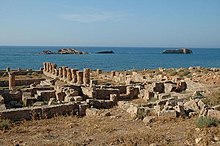
In 96 BC, Rome peacefully obtained Cyrenaica (left as bequeathing by the king Ptolemy Apion) with the so-called sovereign pentapolis, formed by the cities of Cyrene (near the modern village of Shahat), its port of Apollonia, Arsinoe (Tocra), Berenice (near modern Benghazi) and Barce (Marj), that will be transformed into a Roman province a couple of decades later in 74 BC.
We know that at the time of Emperor Domitian, the Nasamones (a Libyan tribe living south of Leptis Magna) rebelled, bringing destruction and defeating the Legatus legionis of Augusta III Cneo Suelli Flacco, who had gone to meet them.
The Greek and Roman populations were massacred: the 4th-century Christian historian Paulus Orosius records that the violence so depopulated the province of Cyrenaica that new colonies had to be established by Hadrian: The Jews ... waged war on the inhabitants throughout Libya in the most savage fashion, and to such an extent was the country wasted that, its cultivators having been slain, its land would have remained utterly depopulated, had not the Emperor Hadrian gathered settlers from other places and sent them thither, for the inhabitants had been wiped out.
Some centuries later in Cyrenaica, Monophysite adherents of the Coptic Church welcomed the Muslim Arabs as liberators from Byzantine oppression.
Anicius Faustus was appointed legatus of the Legio III Augusta and built several defensive forts of the Limes Tripolitanus in Tripolitania, among which Garbia [9] and Golaia (actual Bu Ngem)[10] in order to protect the province from the raids of nomadic tribes.
As a consequence the Roman city of Ghirza, situated away from the coast and south of Leptis Magna, developed quickly in a rich agricultural area.
Anicius Faustus had been fighting against the Garamantes along the Limes Tripolitanus for five years, capturing several settlements from the enemy such as Cydamus, Gholaia, Garbia, and their capital Garama – over 600 km south of Leptis Magna.
As a Roman province, Libya was prosperous, and reached a golden age in the 2nd century AD, when the city of Leptis Magna rivalled Carthage and Alexandria in prominence.
These structures are still visible[15] As a consequence the area south of Leptis Magna became an important exporter of olive oil and cereals to Rome and the province was greatly "romanized", according to Theodore Mommsen.
[16] Tripolitania was a major exporter of agricultural products, as well as a centre for the gold and slaves conveyed to the coast by the Garamentes, while Cyrenaica remained an important source of wines, drugs, and horses.
[18] During the following years, under the smart general Solomon, who combined the offices of both magister militum and praetorian prefect of Africa, Roman rule in Libya was strengthened (Theodorias was refounded [19]), but the fighting continued against the Berber tribes on the hinterland.
Eventually, under Heraclius, Libia and Africa would come to the rescue of the Empire itself, deposing the tyrant Phocas and beating back the Sassanids and the Avars.
Tripoli fell again in 666 AD, and this time the Muslims ensured their control of their new lands by not immediately retreating to Egypt after the conquest.