Russian conquest of Central Asia
The majority of this land became known as Russian Turkestan—the name "Turkestan" was used to refer to the area due to the fact that it was and is inhabited by Turkic peoples, excluding the Tajiks, who are an Iranian ethnicity.
Upon witnessing Russia's absorption of the various Central Asian realms, the British Empire sought to reinforce India, triggering the Great Game, which ended when both sides eventually designated Afghanistan as a neutral buffer zone.
This region now comprises Kazakhstan in the north, Uzbekistan in the centre, Kyrgyzstan in the east, Tajikistan in the southeast, and Turkmenistan in the southwest; the Russian language is still recognized in some capacity in many of these countries.
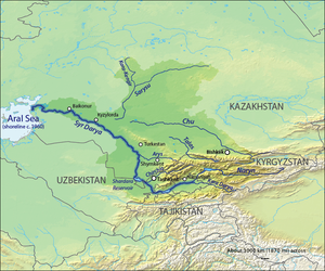
The Oxus or Amu Darya rises on the Afghan border and flows northwest into the Aral Sea, forming a large delta which was ruled by the Khanate of Khiva and has a long history under the name of Khwarezm.
The Jaxartes or Syr Darya rises in the Ferghana Valley and flows northwest and then west to meet the northeast corner of the Aral Sea.
By the late eighteenth century Russia held a line of forts roughly along the current Kazakhstan border, which is approximately the boundary between forest and steppe.
On May 22, 1714, Buchholz, then a lieutenant colonel, received the following Imperial decrees signed by Peter I on the St. Natalia galley: “On the capture of the city of Erket and on the search for golden sand along the Darya River” (Amu Darya), “On sand gold in Bukhara, about the departures made for this, and about the construction of fortresses along the Irtysh River, which are named: Omskaya, Zhelezenskaya, Yamyshevskaya, Semipalatnaya, Ust-Kamenogorsk.
There he had to stop for the winter, build a fortress, leave a garrison in it, and then continue on his way to the city of Erket (Yarkand), where there were supposedly placers of sand gold.
On December 15, 1715, the lieutenant colonel did not dare to go further and wrote to Peter I that it was dangerous to meet the Dzungars with such a small number of troops, but the letter did not reach the sovereign on the Ingermanlandia ship until August 7, 1716.
[5] Dissatisfied with the appearance of Russian troops, the Dzungar Khuntaiji Tsewang-Rabtan sent Buchholz a demand to leave, and when the latter did not obey, on the night of February 10, 1716, he attacked the Yamyshev fortress with his 10,000-strong army and recaptured a herd of horses.
The khan pretended to surrender to him, welcomed him warmly, persuading him to divide the Russian army to dwell in five separate towns in order to facilitate foraging.
The Tsarist government decided to send three detachments to suppress the Kenesary uprising: from the side of the Orsk fortress, the Ulytau mountains and from the Tobol River.
[11] Kenesary and now decided to send only a small detachment against the Russians as a barrier, and prepare the main forces for a decisive blow behind enemy lines.
On August 14, detachments led by the batyrs Nauryzbay and Agybay laid siege to the Ekaterininsky fortress, where about 100 soldiers and a huge number of trophies were taken prisoner, including 1847 pounds of bread:[13] “At a distance of four kilometers from the Catherine Stanitsa, about two thousand Sarbazes of Kenesary gathered.
Experiencing exceptional difficulties in unaccustomed, waterless deserts and sands and having achieved nothing significant in the fight against Kenesary, the Russian detachments were forced to withdraw back towards Orenburg and Omsk.
The three co-rulers wanted to restore the relative independence that was present under previous Kazakh rulers such as Abu'l-Mansur, and they sought to resist taxation by the Russians.
The area was ruled by the Beg of Ak Mechet who taxed the local Kazakhs who wintered along the river and had recently driven the Karakalpaks southward.
Next summer the Russians assembled a force of over 2000 men, over 2000 each of horses, camels and oxen, 777 wagons, bridging timber, pontoons and the steamer Perovsky.
The next question was whether Russia would extend the line east to the mountains (Fort Vernoye was founded in 1854) or continue southeast up the river to Kokand and the Ferghana Valley.
In 1864–68 they moved south, conquered Tashkent and Samarkand, confined the Khanate of Kokand to the Ferghana valley and made Bokhara a protectorate.
In 1864 Alimkul tried to raid the territory of the Russians and recapture the occupied lands, but at Ican his army got in front of a hundred Cossacks and as a result he had to retreat.
The Bokharan Amir did not fully control his subjects, there were random raids and rebellions, so Kaufmann decided to hasten matters by attacking Samarkand.
According to the Bregel's Atlas, if nowhere else, in 1870 the now-vassal Khanate of Bokhara expanded east and annexed that part of Bactria enclosed by the Turkestan Range, the Pamir plateau and the Afghan border.
Veryovkin left from Orenburg, had little difficulty moving along the west side of the Aral Sea and reached the northwest corner of the delta in mid-May.
Unlike the rather antiquated armies of the Khanates, the Turkomans were good raiders and horsemen, but they could do little against the Russians' modern weapons and explosive artillery.
On the Chinese side the Borohoro Mountains branch off creating the upper Ili River valley with its capital of Kulja (modern Yining City).
Some talked of permanent occupation but the Russian Foreign Office told the Chinese that the province would be returned as soon as the Emperor could send enough troops to maintain order.
In 1876 Skobelev chased a rebel south to the Alay Valley and Kostenko went over the Kyzylart Pass and mapped the area around Karakul Lake on the northeast part of the plateau.
During the Russo-Persian War (1804–13) both British and French agents were active in Persia, their goals varying depending on which power was allied with Russia at the time.
On the Chinese side of the mountains a line of passes corresponding the Karakoram Highway provided a trade and pilgrim route from the Tarim Basin to India.


White areas are thinly-populated desert.
The three northwest-tending lines are, from south to north, the Kopet Dagh mountains and the Oxus and Jaxartes Rivers flowing from the eastern mountains into the Aral Sea.


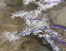
Right: Tarim Basin
Left: part of Afghanistan, Hindu Kush, Bactria, Turkestan Range, Ferghana Valley, main range of the Tien Shan