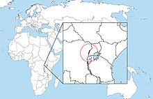
Rwenzori Mountains
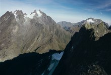
The highest peak of the Ruwenzori reaches 5,109 metres (16,762 ft), and the range's upper regions are permanently snow-capped and glaciated.
[1] Because of this, European explorers linked the Ruwenzori with the legendary Mountains of the Moon, claimed by the Greek scholar Ptolemy as the source of the Nile.
The mountains formed about three million years ago in the late Pliocene epoch and are the result of an uplifted block of crystalline rocks including gneiss, amphibolite, granite and quartzite.
[6] In 1906, the Duke of Abruzzi mounted an expedition to the Ruwenzori, the account of which was subsequently published by Filippo De Filippi.
[9] Since Uganda's independence from the British Empire, the Rwenzori Mountains have repeatedly become sanctuaries to rebel groups.
[11] In the Bush War's later stages, the National Resistance Army (NRA) rebel force operated in the mountains.
[14] In the early 1990s, a Congolese rebel group known as the National Council of Resistance for Democracy (Conseil National de Résistance pour la Démocratie, CNRD) led by André Kisase Ngandu began to wage an insurgency against Mobutu from the Rwenzori Mountains.
[5] There is no water shortage in the Ruwenzori; yet, several members of the afro-alpine family resemble species that normally thrive in desert climates.
To counter the effects of freezing, the afro-alpine plants have developed the insulation systems that give them such a striking appearance.
[21][22][23] In 2012, 2020 and 2022; Klaus Thymann led an expedition with the environmental charity Project Pressure creating comparative photographs to visually document the glacier recession, the findings were published in global media including BBC One Planet,[24] The Guardian[25] and Yale Environment 360.