San Bruno Mountain
Radio Peak (elevation 1,319 feet or 402 meters),[1] the highest point, hosts radio/TV broadcast towers serving the hilly Bay Area.
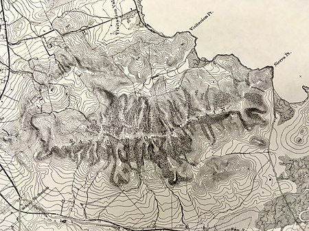
Radio towers occupy the highest (1,319 ft) peak, and may be accessed from the San Bruno County Park center, in the "saddle" between the north and south ridges.
Finally, Serpentinite outcrops occur near Serbian Ravine and at Point San Bruno; this California State Rock is a greenish soft metamorphic material; .
[15] The region is drained by two streams: Guadalupe Valley Creek flows east between the two ranges to reach the Bay north of Brisbane - most of it now runs through underground culverts.
[20] An inland sand-dune (Colma formation) is found on the western slope behind Daly City's John F. Kennedy Elementary School, more than two-and-a-half miles from the ocean and elevated more than seven hundred feet above sea-level.
Summer temperatures are further affected by marine fog shrouding the mountain mornings and evenings between late June and October, particularly the western slopes.
[28][29][30] The northern end of the San Francisco peninsula was primarily covered by plant communities of the grasslands, coastal scrub, redwood and mixed evergreen forest types prior to being overtaken by urban development.
[31] Along the San Francisco Bay, most of the original wetlands have been filled in by sediment from inland human activities (hydraulic mining, dredging, farmland runoff) and by purposeful landfill.
The mineral content of the underlying rock and the high velocity marine air have evolved unusual varieties of flora and sustained specialized fauna that live among them.
Used for windbreaks, shade, and firewood, their ability to thrive and grow quickly in very dry conditions got them planted throughout California in the late 19th and early 20th centuries; increased populations of the monarch butterfly and several bird species were side-effects.
[37] After the Oakland firestorm of 1991, many localities (including San Bruno Mountain State and County Park) began projects to reduce or eliminate eucalyptus stands.
The Yelamu seasonal hamlet of Siplichiquin occupied the southeastern point of the mountain, sheltered from western breezes and facing an oyster-laden cove; the occupants covered their dead with the shells.
[40] Tested samples from the Siplichiquin shellmound indicate regular and continuous occupation from 3,200 BCE [41] (contemporary with the earliest dynasties of Ancient Egypt; and possibly a Hokan or early Penutian settlement pre-dating the Ohlone[42]) through AD 1800.
[44] On December 2, 1774, Alta California governor Fernando Rivera y Moncada and four soldiers (possibly with Father Palóu) climbed the mountain and watched the sun rise across the bay.
Its northern extremity included "La Portezuela" (Doorway) the pass between the western end of the mountain and the coastal upthrust along the San Andreas Fault, the juncture of Mission Street and El Camino Real.
Rancho Canada de Guadalupe la Visitacion y Rodeo Viejo, however, contained most of the present day San Bruno Mountain.
Leese exchanged it for a rancho near Clear Lake owned by Yerba Buena character Robert T. Ridley and his wife Presentacion (daughter of Juana Briones de Miranda).
Despite claims by his widow,[50] the bulk of the grant (including the mountain) was acquired by property-attorney and Land-Commissioner Alfred Wheeler, and subsequently transferred to Henry R. Payson in 1855.
The Chinese Six Companies established Hoy Sun Ning Yung Cemetery in 1898,[57] while the most recent (and sixteenth) development is the neighboring Golden Hill Memorial Park & Funeral Home, begun in 1994.
Radio transmitters presently on San Bruno Mountain include KIOI, KITS, KMEL, KMVQ, KOSF (formerly KSFX), KQED, and KSAN, In 1954, construction was begun for an early-warning radar and missile-control site on the mountaintop.
[61] In 1965, Westbay Community Associates announced a plan to level a portion of the mountain to fill 27 square miles (70 km2) of San Francisco Bay north of Sierra Point with landfill.
[63] Opposition by organizations such as Save The Bay[64] and the residents of Brisbane led to the defeat of Westbay's conveyor plan in June 1967 and eventual cessation of landfill operations at Sierra Point by December 1972.
Visitacion and Crocker Land hired Los Angeles legal firm Nossaman LLP, and in 1982 environmental attorney Robert D. Thornton pioneered the Habitat Conservation Plan (HCP) concept.
An HCP is "a planning document designed to accommodate economic development to the extent possible by authorizing the limited and unintentional take of listed species when it occurs incidental to otherwise lawful activities".
[75] SunChase agreed to fund ecological restoration to mitigate the impact of Terra Bay during the development of Phase I under the terms of the San Bruno HCP.
Presently, real-estate developer Orchard Partners, LLC[90] (of Lafayette, CA) has a purchase-contract and proposed a plan to construct a million-plus square foot warehouse facility in the quarry's footprint and surrounding privately-owned mountainside.
[91] The proposal includes a 36-acre conservation easement and "will dedicate 46 acres with long-term maintenance to the San Bruno Mountain State and County Park".
[94] Over the years, people sought refuge on the mountain from modern society and the homeless support system; [95] some claimed to have cleared invasive or aggressive florae, performed fire prevention services, and engaged with local visitors who passed by their huts.
San Bruno Mountain Watch has questioned governments' approaches to land management and the surrounding communities, and has promulgated the stories of these "hermits" in this context.