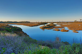
San Elijo Lagoon
Shell middens, the refuse of hunting-gathering societies, show the earliest inhabitants relied heavily on coastal resources, including foods such as scallops, clams, shark, barracuda, bonito, and abalone.
The most permanent changes were the construction of the Santa Fe Railroad's Surf Line in 1887, Pacific Coast Highway 101 in 1891, and Interstate 5 in 1965.
[3] The lagoon lies within the southernmost part of the city of Encinitas and is bordered by Solana Beach on the south and Rancho Santa Fe inland and the Pacific Ocean to the west.
The Reserve is managed by the California Department of Fish and Game,[4] the County of San Diego,[5] and Nature Collective.
Within its approximately 54,000 acres (22,000 ha), stretching from the foothills to the coastline, the last remnants of an imperiled coastal scrub habitat connecting the northern and southern parts of an important ecological region.
This coastal scrub habitat is vital to San Diego County's open space network and to the persistence of some of Southern California's most endangered species, many of which occur nowhere else.
Eight miles (13 km) of trails, open from dawn until dusk, wind through distinct plant communities of San Elijo Lagoon Ecological Reserve.
A short hike to see the wetlands begins at the Nature Center in a 1⁄4-mile (0.40 km) loop with views of the lagoon and salt marsh habitat animal sightings.
Successful efforts by County of San Diego, State of California, and Nature Collective have greatly improved water quality, habitat, and biodiversity.
There are actively maintained projects that focus on water quality testing, habitat restoration, invasive plant removal, and bird counts.
The lagoon’s mouth, located at Cardiff State Beach, is mechanically dredged and reopened each spring following the last winter storm.