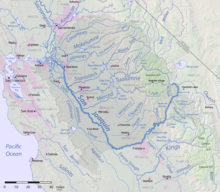
San Joaquin Valley
Famed as a major breadbasket,[1] the San Joaquin Valley is an important source of food, producing a significant part of California's agricultural output.
[4] It extends from the Sacramento–San Joaquin River Delta in the north to the Tehachapi Mountains in the south, and from the California coastal ranges (Diablo and Temblor) in the west to the Sierra Nevada in the east.
[7] About 5 million years ago, the marine outlets began to close due to uplift of the coastal ranges and the deposition of sediment in the valley.
The San Joaquin Valley has extremely hot, dry summers and pleasantly mild winters characterized by dense tule fog.
[17] The Santa Rosa Rancheria belongs to the federally recognized Tachi Yokuts tribe and is located 4.5 miles (7.24 km) southeast of Lemoore, California, in the San Joaquin Valley.
[23][24] In 2011 Forbes, after taking the fluctuation of median home values, five of the top twenty "most miserable cities" were located in the San Joaquin Valley.
[25] Aside from the collapse of median home values, persistent crime, unemployment and poverty were common factors between Bakersfield, Fresno, Merced, Modesto and Stockton – every major city of the San Joaquin Valley.
The San Joaquin Valley has—by California standards—an unusually large number of European, Middle Eastern, and Asian ethnicities in the heritage of its citizens.
Ethnic groups found in a broader area are Portuguese, Germans, Armenians, Basques, and the "Okies" of primarily English and Scots-Irish descent who migrated to California from the Midwest and South.
[citation needed] The San Joaquin Valley has a large and exceptionally diverse Asian American population; primarily from the regions of Punjab in India and Pakistan, the Philippines, and Southeast Asia, especially Laos and Cambodia.
To this day, Punjabi is the third most spoken language in the San Joaquin Valley region, after English and Spanish,[31] and the first Sikh Gurdwara was founded in Stockton in 1915.
Following abolition of immigration restrictions from Asia in the 1960s and 1970s, large numbers of Pakistanis and Indians from Punjab, Gujarat, and Southern India have settled in these valley communities including Modesto, Livingston, Fresno, Stockton, and Lodi.
Those who remained experienced continuing deterioration of conditions, which reached their nadir during the drought that began in the late 1920s and created the infamous Dust Bowl.
Country music legends Buck Owens (from Texas) and Merle Haggard came out of Bakersfield's honky-tonk scene and created a hard-driving sound that is still deeply associated with the city.
Walnuts, oranges, peaches, garlic, tangerines, tomatoes, kiwis, hay, alfalfa and numerous other crops have been harvested with great success.
As areas such as Chino and Corona have become absorbed into the suburban sprawl of Los Angeles, many dairy farmers have cashed out and moved their herds to Kings, Tulare, and Kern counties.
[35] Although there have been some token efforts at confronting the problems of (sub)urban sprawl, the politically conservative climate of the Valley generally prefers traditional suburban sprawl type of growth such as low density housing and strip malls anchored by so-called big box stores and opposes measures such as "Smart Growth", "Transit Oriented Development", "High Density Housing", and increased public transit such as light and commuter rail.
Farmers began using complex irrigation systems and using treated waste water to feed crops, while many were switching from farming cotton to other commodities, chief among them, almonds.
[39] The isolation and vastness of the San Joaquin Valley, as well as its poverty and need for jobs, have led the state to build numerous prisons in the area.
Once distinctly and fiercely independent of Los Angeles and San Francisco, the area has seen increasing exurban development as the cost of living forces young families and small businesses further and further away from the coastal urban cores.
Bakersfield, traditionally a boom-bust oil town once described by urban scholar Joel Kotkin as an "American Abu Dhabi," has seen a massive influx of former Los Angeles business owners and commuters, to the extent that gated communities containing million-dollar homes are going up on the city's outskirts.
The San Joaquin Valley is also the location of the planned initial operating segment of the California High-Speed Rail (CAHSR) project, which will run 171 miles from Bakersfield in the south to Merced in the north.
[citation needed] Population growth has caused the San Joaquin Valley to rank with Los Angeles and Houston in most measures of air pollution.
[46] Only the Inland Empire region east of Los Angeles has worse overall air quality, and the San Joaquin Valley led the nation in 2004 in the number of days with quantities of ozone considered unhealthy by the Environmental Protection Agency.
[46] The San Joaquin Valley has been deemed an "extreme non-attainment zone" by the Environmental Protection Agency, meaning residents are exposed to air quality that is confirmed to be hazardous to human health.
[55] The American Lung Association attributes the noxious gas in the San Joaquin Valley to roughly 1,300 premature deaths every year, including public impacts such as lost days of school or work and emergency room visits.
[64] Nitrates are of concern because it interferes with the blood's ability to carry oxygen, and can have severe health effects on pregnant women, infants under 6 months, and children using tap water for their formula.
In 2011, the Stockton city council asked its waterworks for grants and other sources of funding of $4.6 million to add fluoride to water that will serve approximately 280,000 people.
[71] The Valley has been the home to many country, nu metal, and doo-wop musicians and singers, such as Buck Owens, Merle Haggard, Billy Mize, Korn, Red Simpson, Dennis Payne, Tommy Collins, The Maddox Brothers and Rose, The Paradons, The Colts, and the Sons of the San Joaquin.
[73] The Valley also has a strong literary tradition, heavy in poetry, producing many famous poets such as Sherley Anne Williams, and Gary Soto, former U.S.