Satellite geodesy
These missions led to the accurate determination of the leading spherical harmonic coefficients of the geopotential, the general shape of the geoid, and linked the world's geodetic datums.
[1]: 6 Soviet military satellites undertook geodesic missions to assist in ICBM targeting in the late 1960s and early 1970s.
Observations of satellites in the 1970s by worldwide triangulation networks allowed for the establishment of the World Geodetic System.
The development of GPS by the United States in the 1980s allowed for precise navigation and positioning and soon became a standard tool in surveying.
[1]: 7 Dedicated satellites were launched to measure Earth's gravity field in the 2000s, such as CHAMP, GRACE, and GOCE.
The most prominent system, GPS, consists of a constellation of 31 satellites (as of December 2013) in high, 12-hour circular orbits, distributed in six planes with 55° inclinations.
Each satellite transmits a precise ephemeris with information on its own position and a message containing the exact time of transmission.
Conversely, if the observer's position is precisely known, then the orbit of the satellite can be determined and used to study the Earth's gravity.
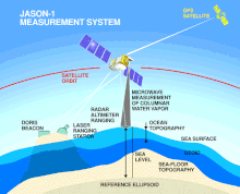
Satellite laser ranging is a proven geodetic technique with significant potential for important contributions to scientific studies of the Earth/Atmosphere/Oceans system.
It is the most accurate technique currently available to determine the geocentric position of an Earth satellite, allowing for the precise calibration of radar altimeters and separation of long-term instrumentation drift from secular changes in ocean surface topography.
The two different wavelengths of radio waves used permit the altimeter to automatically correct for varying delays in the ionosphere.
Spaceborne radar altimeters have proven to be superb tools for mapping ocean-surface topography, the hills and valleys of the sea surface.
Combining these data with the precise location of the spacecraft makes it possible to determine sea-surface height to within a few centimeters (about one inch).
The strength and shape of the returning signal also provides information on wind speed and the height of ocean waves.
A laser altimeter uses the round-trip flight-time of a beam of light at optical or infrared wavelengths to determine the spacecraft's altitude or, conversely, the ground topography.
This geodetic method uses two or more synthetic aperture radar (SAR) images to generate maps of surface deformation or digital elevation, using differences in the phase of the waves returning to the satellite.