Saw Mill River
In the 1920s, the last half-mile (800 m) of the stream was routed into tunnels and culverts under downtown Yonkers, a process partially reversed in the early 21st century when it became the first major New York waterway to be daylighted.
Just west of the Chappaqua train station, it turns southwest to parallel both the parkway and Metro-North Railroad's Harlem Line[10] as both cross into the town of Mount Pleasant.
Both turn south again, then southeast, following the eastern edge of the Pocantico Hills,[16] joined on the west by the North County Trailway bike path, on the right-of-way of the former New York and Putnam Railroad, known as the "Old Put".
[21] Here the bike path ends amidst the dense urban development,[22] but the parkway continues, and the two again draw close as they enter the town of Greenburgh and intersect the Cross Westchester Expressway (Interstate 287).
[33] As every one may not recognize these boundaries by their original Indian names, it may be well to observe, that the Neperan is that beautiful stream, vulgarly called the Saw-Mill River, which, after winding gracefully for many miles through a lovely valley, shrouded by groves, and dotted by Dutch farm-houses, empties itself into the Hudson, at the ancient drop of Yonkers.
After passing the towers of a large housing project to its west, it is routed into a tunnel at Chicken Island,[36] the triangle between Nepperhan and Palisade avenues and School Street.
[36] The Saw Mill's 26.5-square-mile (69 km2) watershed is limited by the hilly topography of central Westchester County to a valley that averages 1.4 miles (2.3 km) wide; the only wider spots are the Mine Brook and Tarrytown Lakes subwatersheds and the river's mouth in downtown Yonkers.
[44] Seven years later, Dutch settler Adriaen van der Donck was granted part of this land, including the southern section of what he named the Saeck-kill,[45] today's Saw Mill River.
[46] In the 1670s, part of Donck's land passed to Frederick Philipse, who was rewarded with 90,000 acres (360 km2), including the lower river, for declaring his loyalty to the new British rulers of New Netherlands.
In 1750, his great-grandson Frederick III inherited the whole property and moved from his New York City townhouse to the manor hall, previously used as the family's summer home.
Quakers had been immigrating to Long Island since the previous century to escape religious persecution in England; in the 1700s, "Shapequaw", north of the present hamlet of Chappaqua, was established.
He was arrested in August 1776 and held in Connecticut until a parole grant at the end of the year allowed him to return home as long as he did nothing to support the British war effort.
In November 1777, three young men with Patriot sympathies were walking near the river crossing on the Dobbs Ferry Road (now Ashford Avenue) when they came upon a group of horsemen affiliated with Kipp's Regiment, one of the county's most-feared Loyalist militias.
[50] On the British side, Major John André spent his last night before his capture, with documents exposing Benedict Arnold's betrayal, at the Rookery inn in Hawthorne.
In January, one company of about 250 troops from Massachusetts lingered long enough at Four Corners for local Loyalists to inform the British, who raised a force of about 100 cavalry and 400 to 500 infantry at Fort Washington, today on the northern tip of Manhattan.
The outnumbered Continentals put up stiff resistance, aided by the cold, heavy snow cover and their opponents' fatigue, but most were ultimately killed or taken prisoner.
The British and their Loyalist and Hessian allies celebrated by burning down the Young house; the Continentals retreated to the north of the Croton River for the rest of the war.
Between the rocky soil and Wells' general refusal to sell or lease most of his land, there were so few settlers in Yonkers that two schoolhouses built during the Revolution fell into severe neglect due to the lack of students.
[54]: 19–25 Over the next several decades, as Yonkers' population grew rapidly, leading it to incorporate as a village and then, in 1872, a city,[54]: 25–28 the rest of the estuary was filled in and narrowed and the bluffs on its south side graded out of existence.
So much pollution was dumped into the river from the factories alongside it that a local poet lamented the Saw Mill's decline in an 1891 quatrain: 'Tis now, at Yonkers's spreading feet,A flow with odorous sins replete;Its nitid bosom has becomeA snake-like yellow scrawl of scum.
"A great many privies and cesspools are located on the edge of the Saw Mill and its tributaries and there is also drainage from poultry yards, barnyards and house drains," the department noted[60] Rather than enforce the violated regulations more strictly and clean up the river, the city chose to cover it up entirely.
[66] Westchester District Attorney Jeanine Pirro brought criminal environmental charges against American Sugar Refining, the plant owner, which was forced to pay a $20,000 fine; make a $100,000 donation to Riverkeeper, a regional environmental organization that focuses on the Hudson and its tributaries; and give 1 short ton (910 kg) of sugar to Westchester Food-PATCH, a local nonprofit that supplies food to other nonprofits.
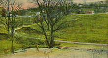
Near Ardsley and Dobbs Ferry and Irvington, the river passes through V. Everit Macy Park, popular for picnicking and fishing in Woodlands Lake.
[4][6] A 1983 United States Geological Survey (USGS) study found that concentrations of heavy metals in the water increased further downstream, a phenomenon observed with many other pollutants in the river and correlated with the urbanization around and above its mouth.
[1]: 10 In regulations adopted in 1985 and amended in 2008, New York's Department of Environmental Conservation (DEC) divides the river into four water-quality regions similar to those in the 1983 USGS study.
[86] A 1991 study by Irene Gruenfeld, a Williams College undergraduate, measured various pollutants at eight points along the river, from just below the duck pond in Chappaqua to inside the tunnel in Yonkers.
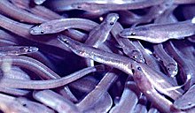
While the PCBs in the river were found somewhat biodegraded, chlordane levels are high enough that DEC recommends eating no more than a half-pound (230 g) of fish or eel from the Saw Mill per month.
[65] The Army Corps of Engineers found that the channeling prevented aquatic life from sustaining itself; few fish naturally spawn in the river because of the cement casing and culvert at its mouth.
Most of the high coliform readings came after rainfall except at the two sites furthest downstream; the study theorized that some older buildings in this area of Yonkers may still discharge sewage directly to the river.
Between the end of the tunnel and Woodlands Lake, the river was still found to be impaired for recreation, drinking and aquatic life, but less strewn with litter, and as a whole the habitat was merely stressed.