Hurricane Irene
[3] It remained well-defined while moving steadily westward for several days to the south of the Cape Verde Islands, although at the time any notable convection occurred well to the southwest of its axis.
[5] On August 19, the convective structure began to show signs of organization as the associated atmospheric pressure lowered, and with a progressively favorable environment situated ahead of the wave its chances of undergoing tropical cyclogenesis markedly increased.
[9] Irene was positioned about 190 mi (310 km) east of Dominica in the Lesser Antilles when it was classified and named, along weakening high pressure over the west-central Atlantic, inducing a roughly west-northwestward path for most of its journey through the eastern Caribbean.
With the improved structure, as well as light wind shear and high sea surface temperatures, Irene was forecast to strengthen to near hurricane force prior to landfall in Hispaniola.
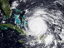
Moving erratically through the southeast Bahamas over very warm waters,[20] Irene quickly expanded as its outflow aloft became very well established; the cyclone intensified into a Category 3 major hurricane as it recurved toward the northwest along a weakness in the subtropical ridge.
[23] At 7:30 am EDT (11:30 UTC) on the same day, Irene made landfall near Cape Lookout, on North Carolina's Outer Banks, with winds of 85 mph (137 km/h), but exhibited an unusually low pressure of 951 mbar, which is typically found in a category 3 hurricane.
[citation needed] Following its final New York landfall, Irene moved northeast over New England while maintaining its strength, before it was declared an extratropical cyclone early on August 29, while its center was located near the New Hampshire/Vermont border.
[40] Due to the threat, state officials, as well as utilities, transportation facilities, ports, industries, oil refineries, and nuclear power plants, promptly prepared to activate emergency plans; residents in the areas stocked up on food supplies and worked to secure homes, vehicles and boats.
[41] States of emergency and hurricane warnings were declared for much of the East Coast, including North Carolina,[42] Virginia,[42][43] Maryland,[43] Delaware,[44] the District of Columbia,[45] Pennsylvania,[46] New Jersey,[42] New York,[42] Connecticut,[47] Rhode Island,[48] Massachusetts,[49] Vermont,[50] New Hampshire,[51] and Maine.
[70] By August 25, dozens of vessels at the Norfolk and Newport News shipyards began to evacuate or prepare to weather the storm, including the carriers Enterprise, Dwight D. Eisenhower, Harry S. Truman, Theodore Roosevelt,[71] and the construction site of the Gerald R. Ford.
[85] Philadelphia mayor Michael Nutter expressed concern that there could be severe devastation in the city and surrounding areas,[86] and Governor Tom Corbett declared a state of emergency in Pennsylvania.
[94] To relieve evacuation traffic, toll operations were temporarily suspended on the Garden State Parkway south of the Raritan River and on the Atlantic City Expressway.
[93] Possible rising seawater levels from storm surge and a predicted high tide led to a complete shutdown of the MTA, the nation's largest mass transit system.
[114] The National Weather Service stated that it anticipated 2–5 inches (51–127 mm) of rain on the Champlain Valley and western Vermont and 3–7 inches (76–178 mm) in the Green Mountains and eastern Vermont, with the risk of flooding near streams and rivers and an anticipated sustained wind speeds of 30–45 miles per hour (48–72 km/h) and gusts of up to 45–65 miles per hour (72–105 km/h), causing significant tree damage and damage to power lines.
[124] Passing near the British Virgin Islands while strengthening, Irene brought gusty winds and heavy precipitation to the territory; however, resultant property damage was minimal.
[125] A lightning strike over Necker Island sparked a large fire at one of business magnate Richard Branson's resort homes, but all of its guest occupants—including British actress Kate Winslet—were able to exit the area.
[127] Across Puerto Rico, heavy rains caused extensive damage to roads while hurricane-force winds toppled many trees and utility poles, which led more than 1 million residences without power.
[141] Skirting barely north past Hispaniola, the large storm produced gales and prolonged precipitation in the Dominican Republic, displacing over 37,700 people and leaving at least 88 communities isolated in its wake.
In addition, waves of 10 to 12 feet (3.0 to 3.7 m) high were seen in Gibara, Holguín, on Wednesday 24, when Irene's eye was located between Acklins and Crooked Islands, Bahamas, just 178 miles (286 km) northeast of the city.
[165] Across New Providence and Grand Bahama, only limited impact occurred as Irene remained well offshore; businesses operations were scheduled to return to normal shortly after the storm.
The winds, combined with soil saturation due to the extreme amounts of precipitation in many of the impacted areas both from Irene and from previous thunderstorms, uprooted countless trees and power lines along the storm's path.
Brisk winds produced scattered power outages[171][failed verification] and waves reaching as high as 12 ft (3.7 m);[171] rough surf in the Boynton Inlet injured at least eight people,[172] and two surfers were killed offshore Volusia County.
[176] Owing to its unusually large windfield, Irene affected long stretches of South Carolina coastlines with gusts and sporadic heavy showers, even though it remained offshore.
[195] Hurricane Irene caused widespread power outages in Delaware, Maryland, New Jersey, Pennsylvania, and Washington, D.C.[196][197][198] Dorchester General Hospital in Cambridge was evacuated after there was wind and water damage[199] to the laboratory roof.
The workers at Ground Zero in Lower Manhattan worked to make the World Trade Center site hurricane proof, and escaped major damage, just missing the tenth anniversary of 9/11.
[235] Flooding of the Ramapo River and more than a half-mile (1 km) of washouts led both Metro-North and NJ Transit to suspend service on the Port Jervis Line north of Suffern for nearly three months.
[249] Governor Dannel Malloy said Hurricane Irene was responsible for a tenth death on August 28: a man who died in a fire likely caused by downed wires from high winds.
[250] An elderly woman, who resided in Prospect, died in similar situations, when a falling tree caused power lines to collapse onto her home, starting a fire;[169] her husband was critically injured.
On August 28, in Quebec, high winds (more than 110 kilometres per hour (68 mph) in some places) and heavy rainfall from post-tropical storm Irene knocked out power to over 250,000 homes, felled tree branches, and damaged buildings and traffic signals across Montreal.
[303] On account of the high death toll and extensive damage caused by the storm, the name Irene was retired by the World Meteorological Organization in April 2012, and will never again be used for an Atlantic tropical cyclone.

Tropical storm (39–73 mph, 63–118 km/h)
Category 1 (74–95 mph, 119–153 km/h)
Category 2 (96–110 mph, 154–177 km/h)
Category 3 (111–129 mph, 178–208 km/h)
Category 4 (130–156 mph, 209–251 km/h)
Category 5 (≥157 mph, ≥252 km/h)
Unknown